
- Installs
- —
- Apple does not publish download counts
- Rating
- 4.62
- Ratings
- 94
- 94 reviews
- Version
- 10.1.3
- Updated 27 Oct 2026
- Released
- 9 Aug 2011
- Tracked since 10 May 2026
- Size
- 168 MB
- Needs 16.0
Also on Google Play: AvPlan EFB
Screenshots
About AvPlan EFB
The description on the store listing
Get flying faster with AvPlan EFB - the premier lifetime Electronic Flight Bag that grows with you.
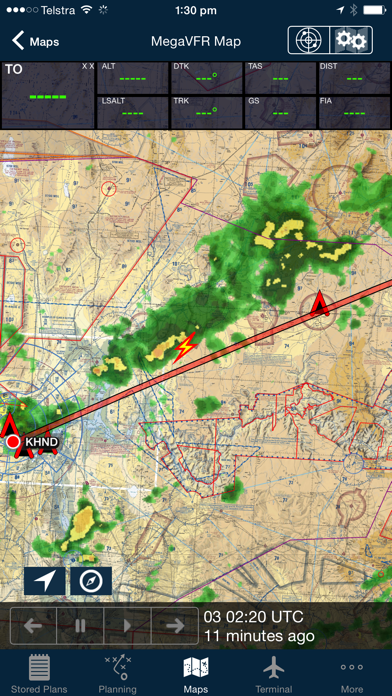
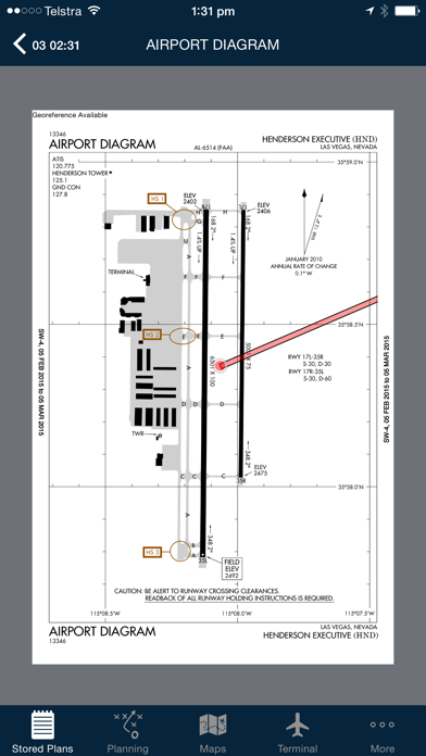
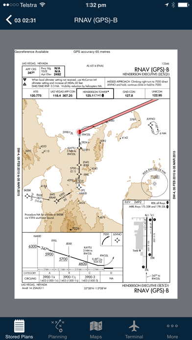
Continuing to lead the market with unparalleled innovation and functionality, AvPlan features multiple firsts with terrain warning, touch to display restricted airspace status, automatic IFR airway planning and geo-referenced airport taxi & instrument approach diagrams to arm you with superior situational awareness.
Envisioned, developed and rigorously tested over a two year period by pilots for pilots, AvPlan EFB integrates everything you need to prepare, plan and execute your flight - whether it be in a recreational aircraft, corporate jet or something in between.
Your AvPlan EFB comes …
Read the full description
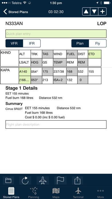
Get flying faster with AvPlan EFB - the premier lifetime Electronic Flight Bag that grows with you. Continuing to lead the market with unparalleled innovation and functionality, AvPlan features multiple firsts with terrain warning, touch to display restricted airspace status, automatic IFR airway planning and geo-referenced airport taxi & instrument approach diagrams to arm you with superior situational awareness. Envisioned, developed and rigorously tested over a two year period by pilots for pilots, AvPlan EFB integrates everything you need to prepare, plan and execute your flight - whether it be in a recreational aircraft, corporate jet or something in between. Your AvPlan EFB comes packed with the following features: • Comprehensive VFR & IFR Flight Planning • Complete official FAA airport/waypoint database • All necessary documentation • Advanced aircraft flight model setup • Automatic TOC, TOD, PNR and optimum altitude calculation • Full DUATS integration (WX, NOTAMS, flight plan submission) • All US VFR & IFR aeronautical charts (with pan, zoom and rotation) • Touch and drag (rubber band) graphical flight replanning/diversion • Weight and balance (with loadsheet and passenger manifest) • Graphical WX overlays on any chart (WX Radar, Lightning, METAR, SIGMET) • GPS moving map with display data labels • Touch-to-display TFR status • Terrain map overlay and in-flight terrain alerting • Geo-referenced airport diagrams (auto displays aircraft position on landing) • Geo-referenced instrument approach plates which support route editing and more • FAA Documentation (including full text search and bookmark functions) • Aircraft pilot operating handbook import • Send a briefing pack to PDF file, email & Apple AirPrint compatible printers • Extensive integration with external flight planning systems/panel GPS/FMS’s (Including Garmin G1000) • Ability to sync flight plans between Apple IOS devices • Easy to access support from a team of committed professionals • And much more we can’t list here The Perfect Co-pilot Intuitive, reliable and responsive, AvPlan’s inbuilt context awareness engine ensures it’s always up to date and ready to provide you with the right information at the right time, whether you’re preparing for your flight or already airborne. Continued use of GPS running in the background can dramatically decrease battery life. AvPlan EFB – Plan faster, fly sooner
Installs since 29 Aug 2026
Apple does not publish download counts. Estimates are in testing.
Estimated store revenue Estimated Beta
App Store, worldwide, monthly rate from the last 12 chart days to 19 Nov 2026
Below the top 100 grossing apps in the markets we calibrate. In the United States that usually means under about $6.4M a month. App Store purchases and subscriptions only, before Apple's 15 to 30% fee. Ads and web payments are not included.
Ratings
94 ratings, 94 reviews
No rating breakdown published for this app.
Recent reviews
Latest public reviews from the store
No reviews in our sample for this app yet.
Top chart positions
Latest App Store chart ranks by country, last 10 days
- Countries ranked
- 2 of 50
- Best rank
- #67
- Top 10 placements
- 0
- of 2 chart placements
- Average rank
- #79.5
Best countries on App Store
- 🇳🇿 New Zealand · Top grossing, Navigation#67
- 🇦🇺 Australia · Top grossing, Navigation#92
| Country | Chart | Category | Rank | Best (10 days) | Date |
|---|---|---|---|---|---|
| 🇳🇿 New Zealand | Top grossing | Navigation | #67 | #5 | 19 Nov 2026 |
| 🇦🇺 Australia | Top grossing | Navigation | #92 | #18 | 19 Nov 2026 |
AvPlan EFB history
Release, install milestones, listing and store changes
- First released on the store 9 Aug 2011
Update frequency
How often AvPlan EFB ships a new version, month by month
4 updates in the last 12 months. More often than most similar apps: they shipped a median of 2 updates in the same year.
Recent versions
Current version 10.1.3
- Version 10.1.327 Oct 2026
• Fix performance issue entering names into load stations • Approved WnB profiles will not clear load station attributes • Resolve issues with entering different passenger names in different load stations in multi stage plans • When adding a user waypoint with spaces in its name, enter it in quotes in the quick route editor • When double-tapping a traffic icon on the map, bring it to the foreground • Resolve an issue where the map shows a blank page when downloading a navdata update New in 10.1.2 • Fill optional equipment forward across stages • Add a report for weight and balance approvers • Resolve a crash when deleting a fix • Add loading indicator on the terminal pane airport list • Show lateral arms on the weight and balance setup page • Resolve an issue where the plan could display a departure time in local time and not UTC New in 10.1.1 • Fixed an issue where flight plans could disappear during synchronisation or after moving between folders. • Improved saving, editing and reuse of named negative-weight entries in weight and balance. • Fixed missing negative-weight entries on printed load sheets. • Fixed sharing and saving load sheets as PDF files. • Corrected fuel units in the trip editor to match the selected aircraft. • Fixed altitude edits being lost when submitting or updating HAAST and Flight Advisor flight intentions. • Improved LSALT boundary menus and save prompts for aircraft changes and weather-service login details. • Prevented empty signatures from being saved. • Improved access to data downloads covered by eligible subscriptions. • Add POB field to the advanced weight and balance page • Update POB when adding passengers • Resolve an issue with advanced tanks using the wrong arm • Resolve a possible crash when the flight plan index updates • Resolve an issue where a stage could be reported out of the envelope, when it actually is not. • Resolve an issue with calculating an arm for fuel level in an advanced tank New in 10.1 • Add MOS Part 135/6 compliant journey log for enterprise customers • Improved GAF display under Weather • Add HAAST for RNZAF • Resolve an issue with the notepad and iOS 27 • Provide multiple auto-routing options prioritising high or low altitude IFR routes • Improvements to the Advanced WnB section • Resolve an issue with distance rings disappearing • Add support for both types of helicopter lateral WnB envelopes • Always print an SPFIB briefing two pages per page • Printing a SPFIB briefing will download a new briefing if one has not already been accessed
- Version 10.0.25 Aug 2026
Added in 10.0.2 • Add Grid LSALT map overlay. Enable under Map Settings • Add ability to view GAF forecast report on the GAF Weather view • Add ability to download SPFIB briefing under Print/Send • Make burning contingency fuel and holding fuel between stages configurable • Add optional label on the mid-point of a leg. Add labels to all route marker types (10nm, 10 min, 6 min etc) • Resolve an issue where GAFs may not update • Resolve an issue creating and editing user waypoints Added in 10.0.1 • Add location to GAF and Satellite views • Burning contingency fuel across stages is now an optional setting for user or enterprise groups • Resolve an issue with the WnB pages and loading profiles • Correctly shade load stations when weights are exceeded • Resolve some stability issues Added in 10.0 • ActivePlates - highlights your location on the vertical profile of RNP approach plates. Highlights the MSA sector and indicates inbound heading to holding patterns. ActivePlates also includes a HUD on the terminal pane which displays the current ground speed, vertical speed required to maintain the published glideslope, the target altitude required to be on the glideslope for your location. The surface winds from the current METAR is also displayed. • Added indication of circuit directions on airport diagrams. These will show correct directions for both day and night operations. • New Weight and Balance display, including a plan view of the aircraft and improved loading of passengers on multi-stage plans. Added an auto-load function for larger aircraft. Added ability to quickly load just the required fuel (for the stage or to the next refuel point). • New synthetic vision display, including airport locations, ADSB traffic, active airspace. Added ability to swipe to move viewport. • New Print/Send functionality. Save preferred documents to print/send preflight and post flight. • Add Tech Log feature for Enterprise customers. Documents can be attached both pre-flight and post-flight and are saved in the AvPlan Cloud. • New optimise altitude function, displaying LSALT and freezing levels. There is now a separate function to optimise the altitude for alternate stages as well. • New GAF display under Weather • New SPFIB briefing functions, including annotations and searching • Added ability to annotate flight plan reports under Planning. Annotated documents can be printed/emailed and archived in the AvPlan Cloud under Print/Send • Approach plate annotations are now also displayed on the map, when overlaying a plate on the map • TAF/METAR/ATIS can be displayed using a button on all plates under Terminal. Additionally, a plate can be added to favourites using a button on all plates.
- Version 10.010 Jul 2026
• ActivePlates - highlights your location on the vertical profile of RNP approach plates. Highlights the MSA sector and indicates inbound heading to holding patterns. ActivePlates also includes a HUD on the terminal pane which displays the current ground speed, vertical speed required to maintain the published glideslope, the target altitude required to be on the glideslope for your location. The surface winds from the current METAR is also displayed. • Added indication of circuit directions on airport diagrams. These will show correct directions for both day and night operations. • New Weight and Balance display, including a plan view of the aircraft and improved loading of passengers on multi-stage plans. Added an auto-load function for larger aircraft. Added ability to quickly load just the required fuel (for the stage or to the next refuel point). • New synthetic vision display, including airport locations, ADSB traffic, active airspace. Added ability to swipe to move viewport. • New Print/Send functionality. Save preferred documents to print/send preflight and post flight. • Add Tech Log feature for Enterprise customers. Documents can be attached both pre-flight and post-flight and are saved in the AvPlan Cloud. • New optimise altitude function, displaying LSALT and freezing levels. There is now a separate function to optimise the altitude for alternate stages as well. • New GAF display under Weather • New SPFIB briefing functions, including annotations and searching • Added ability to annotate flight plan reports under Planning. Annotated documents can be printed/emailed and archived in the AvPlan Cloud under Print/Send • Approach plate annotations are now also displayed on the map, when overlaying a plate on the map • TAF/METAR/ATIS can be displayed using a button on all plates under Terminal. Additionally, a plate can be added to favourites using a button on all plates.
- Version 9.1019 Feb 2026
• Add ability to create/edit user waypoints using NZTM coordinates (for NZ) • Add aircraft instance version to load sheet • Resolve an issue sending a flight plan with long remarks to IFIS • Change some naming of planning options in NZ to better align with NZ terminology • If there is advanced tank data, do not display the arm in the summary • Use underlying class E frequency in current/next FIA frequency box if flying over and not through this airspace • Auto-hide airspace highlighting after 15 seconds • Some stability improvements
Listing keywords
Words and phrases AvPlan EFB repeats most in its store listing
Top phrases: avplan efb (5), geo referenced (3), geo referenced airport (2), touch to display (2), flight planning (2).
Highlighted words also appear in the title. Counts cover the title, short description and description.
Compliance
What the listing and the app package show
- Store status
- Live
- Upkeep
- Updated 27 Oct 2026
- Registered in
- United States
- Age rating
- 4+
Apps like AvPlan EFB
 PRO HUNT™MiraTrex, Inc.★ 4.54
 Japan Travel Guide .Daniel Garcia★ 4.73
 London Travel Guide with MapJorge Herlein★ 4.56
 Тюменские ПарковкиAngels IT★ 4.53
 釣り堀&つり場スポット情報ビジョンマップFARBEYOND LLC★ 4.36
 Street View : 360° AppRajnish Gujarati★ 4.38
 Find My Latitude and LongitudeJason Attard★ 4.53
 GPS Navigation, Map DirectionDivyang Katharotiya★ 4.61
 YanosikNeptis Sp. z o.o.★ 3.74
AvPlan EFB: questions and answers
Who makes AvPlan EFB?
AvPlan EFB is published by BJA Consulting Pty Ltd, a developer based in US.
When was AvPlan EFB last updated?
The latest version (10.1.3) was released on 27 Oct 2026.
Is AvPlan EFB free?
Yes. AvPlan EFB is free to download.
Is AvPlan EFB still available?
Yes. AvPlan EFB is live on App Store as of 14 Nov 2026.
Track AvPlan EFB and its competitors
Watch any app for new versions, rating drops, chart moves and removals. Free plan, no card.