
- Installs
- —
- Apple does not publish download counts
- Rating
- —
- Ratings
- —
- Version
- 1.0.1
- Updated 18 Aug 2026
- Released
- 18 Aug 2026
- Tracked since 31 Aug 2026
- Size
- 5 MB
- Needs 17.6
Screenshots


About FireRadar - Wildfire Map
The description on the store listing
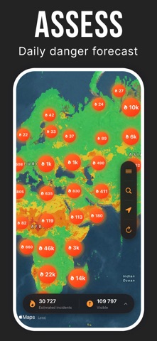
FireRadar helps you monitor wildfires, thermal anomalies and fire danger worldwide through a clear and responsive interactive map.
Explore recent satellite detections, view burned areas and display wildfire danger for today or tomorrow. Select any available item to see more context, including the detection date, satellite source, confidence level and local conditions when available.
A GLOBAL WILDFIRE MAP
View recent thermal detections on a worldwide map. Nearby points may be grouped to keep the map readable when several signals are observed in the same area.
Move freely across the map, zoom into a region and quickly switch from a global overview to a local inspection.
WILDFIRE DANGER …
Read the full description
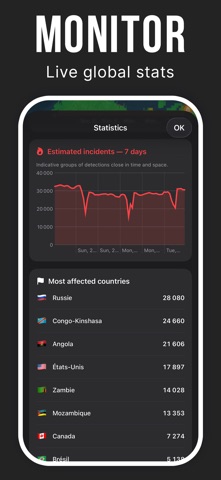
FireRadar helps you monitor wildfires, thermal anomalies and fire danger worldwide through a clear and responsive interactive map. Explore recent satellite detections, view burned areas and display wildfire danger for today or tomorrow. Select any available item to see more context, including the detection date, satellite source, confidence level and local conditions when available. A GLOBAL WILDFIRE MAP View recent thermal detections on a worldwide map. Nearby points may be grouped to keep the map readable when several signals are observed in the same area. Move freely across the map, zoom into a region and quickly switch from a global overview to a local inspection. WILDFIRE DANGER Enable the wildfire danger layer to review conditions for today or tomorrow. The color scale helps you quickly identify areas where fire danger may be higher. The layer is optional, allowing you to display it only when needed and keep the map clear. BURNED AREAS Display recently burned surfaces across Europe, the Mediterranean region and the rest of the world, depending on data availability. Colors make these areas easy to identify without hiding the main geographic references. DETAILED INFORMATION Select a detection to review available details: • detection date and time; • satellite or instrument; • confidence level; • location; • local weather conditions when available. STATISTICS AND COMPARISONS Track changes in detections over several days and compare the countries or regions most affected. Charts make it easier to identify increases or decreases in detected activity. MULTIPLE MAP STYLES Switch between standard, satellite and hybrid maps to match the terrain. Roads, cities and key geographic references remain visible to help you interpret the information. A SIMPLE INTERFACE Environmental layers are disabled by default and can be enabled from the map menu. This gives you full control over the information displayed. FireRadar is available in English and French. SATELLITE DATA FireRadar uses data from sources including NASA FIRMS, VIIRS, MODIS, GWIS and EFFIS. Availability, update frequency and coverage may vary by region and provider. IMPORTANT INFORMATION A satellite detection represents a thermal anomaly observed from space. It does not necessarily confirm a wildfire on the ground. Incidents grouped in the app are estimates based on detections that are close in location and time. Data may be delayed, incomplete, obscured by clouds or temporarily unavailable. Some regions may provide more information than others. FireRadar is an information and visualization tool. It is not a replacement for official alerts, local authorities, weather agencies or emergency services. In an immediate emergency, always follow instructions from the relevant authorities and use your country’s official emergency channels.
Installs
Apple does not publish download counts. Estimates are in testing.
We publish iOS estimates only after they pass a back-test against real numbers. Chart history below is measured.
Estimated store revenue Estimated Beta
App Store, worldwide, monthly rate from the last 12 chart days to 19 Nov 2026
Below the top 100 grossing apps in the markets we calibrate. In the United States that usually means under about $6.4M a month. App Store purchases and subscriptions only, before Apple's 15 to 30% fee. Ads and web payments are not included.
Ratings
No rating breakdown published for this app.
Recent reviews
Latest public reviews from the store
No reviews in our sample for this app yet.
Top chart positions
Latest App Store chart ranks by country, last 10 days
- Countries ranked
- 1 of 50
- Best rank
- #80
- Top 10 placements
- 0
- of 1 chart placements
- Average rank
- #80
Best countries on App Store
- 🇨🇱 Chile · Top free, News#80
| Country | Chart | Category | Rank | Best (10 days) | Date |
|---|---|---|---|---|---|
| 🇨🇱 Chile | Top free | News | #80 | #80 | 13 Nov 2026 |
FireRadar - Wildfire Map history
Release, install milestones, listing and store changes
- First released on the store 18 Aug 2026
Update frequency
How often FireRadar - Wildfire Map ships a new version, month by month
1 updates in the last 12 months. Less often than most similar apps: they shipped a median of 3 updates in the same year.
Recent versions
Current version 1.0.1
- Version 1.0.118 Aug 2026
Listing keywords
Words and phrases FireRadar - Wildfire Map repeats most in its store listing
Top phrases: wildfire danger (3), conditions when available (2), today or tomorrow (2), burned areas (2), confidence level (2).
Highlighted words also appear in the title. Counts cover the title, short description and description.
Compliance
What the listing and the app package show
- Store status
- Live
- Upkeep
- Updated 18 Aug 2026
- Registered in
- France
- Age rating
- 4+
Apps like FireRadar - Wildfire Map
 PúblicoPúblico Comunicação Social, SA★ 4.86
 Gazette TimesLee Enterprises★ 2.06
 SUPERINTERESSANTEAbril★ 4.58
 Tarun Bharat Marathi NewspaperMediology Software Private Limited★ 4.58
 A BOLA – Edição DigitalSociedade Vicra Desportiva, S.A.★ 4.82
 PCN SelectPennsylvania Educational Communications Systems★ 2.02
 WBBJ 7 Eyewitness NewsGray Television Group, Inc.★ 2.74
 e-DNDagens Nyheter★ 4.52
 KBZK NewsE.W. Scripps Company★ 4.66
FireRadar - Wildfire Map: questions and answers
Who makes FireRadar - Wildfire Map?
FireRadar - Wildfire Map is published by David Azancot, a developer based in FR.
When was FireRadar - Wildfire Map last updated?
The latest version (1.0.1) was released on 18 Aug 2026.
Is FireRadar - Wildfire Map free?
Yes. FireRadar - Wildfire Map is free to download.
Is FireRadar - Wildfire Map still available?
Yes. FireRadar - Wildfire Map is live on App Store as of 31 Aug 2026.
Track FireRadar - Wildfire Map and its competitors
Watch any app for new versions, rating drops, chart moves and removals. Free plan, no card.