
- Installs
- —
- Apple does not publish download counts
- Rating
- 4.12
- Ratings
- 907
- 907 reviews
- Version
- 7.1.1
- Updated 24 Jan 2025
- Released
- 24 Oct 2014
- Tracked since 10 May 2026
- Size
- 494 MB
- Needs 14.0
Screenshots





About FlyQ+ EFB
The description on the store listing
FlyQ+ EFB is a top-rated aviation app because it makes your flying easier and safer by thoughtfully integrating powerful features in a way that minimizes the number of screen taps and uses larger fonts to increase readability.
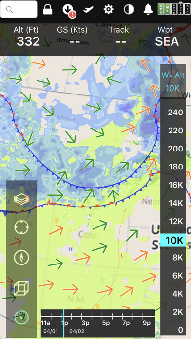
New features such as a glide ring, graphical weather briefing, ability to download two data cycles, and a navlog that expands/collapses airways/SIDs/STARs make flying safer and easier than ever before!
The Global Digital Map shows airports, airways, airspace, navaids, and waypoints from all around the world. Text rotates so it's always right-side up and the level of detail adapts to the zoom level.
Our exceptional "4D Predictive Weather" system uses a Timeline and …
Read the full description
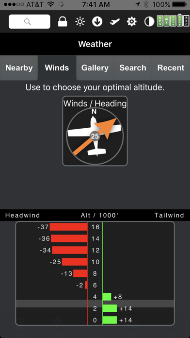
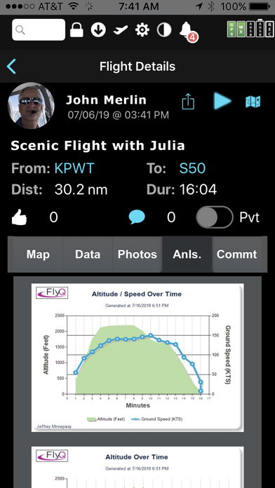
FlyQ+ EFB is a top-rated aviation app because it makes your flying easier and safer by thoughtfully integrating powerful features in a way that minimizes the number of screen taps and uses larger fonts to increase readability. New features such as a glide ring, graphical weather briefing, ability to download two data cycles, and a navlog that expands/collapses airways/SIDs/STARs make flying safer and easier than ever before! The Global Digital Map shows airports, airways, airspace, navaids, and waypoints from all around the world. Text rotates so it's always right-side up and the level of detail adapts to the zoom level. Our exceptional "4D Predictive Weather" system uses a Timeline and Altitude Slider to help you analyze weather at different times - both past and future - and at different altitudes. 17 weather layers from both the Internet and ADS-B (e.g. Radar, Icing, Turbulence, PIREPs, Winds Aloft, Surface Winds, Surface Analysis, Satellite, and more), many tied to the Timeline and Altitude Slider, give you unprecedented pre-flight and in-flight safety. Supports more than 20 ADS-B and in-panel devices: Stratus 3, Avidyne, Dynon, Stratux, and more. The exclusive Augmented Reality (AR) feature provides situational awareness you'd previously only seen in sci-fi movies. The Slingshot wireless system means FlyQ+ supplies maps, plates, and apt diagrams wirelessly to certified systems from BendixKing. The Visual Logbook and Post Flight Playback / Analysis Graphs add a whole new dimension to your flying. Optionally connect with your friends to "see" and even replay their flights. CFI's can track student progress and remotely send endorsements. Other key features include split screen, 3D synthetic vision, plates on the map, more than 4,600 airport diagrams, rich Documents support, extended runways, distance measurement, fuel prices, NOTAMS, wind-optimized flight planning, and plates for Mexico and Central America. NEW! NaviGuard GPS anomaly detection guards against GPS spoofing and jamming > Maps Your Way + Digital, 2D maps, 3D Syn Vis, Augmented Reality + Sectionals and IFR charts + TACs + Photo, road, terrain maps + 17 Weather Layers + Flight Track + Fuel Prices + TFRs + Obstacle and Terrain Avoidance + ADS-B Traffic and Weather + Extended runways with right-pattern indicators + Procedures on map + Rings / Extended Course Line + CAP grid + Heli and Gulf of Mexico charts + VFR Flyways + Syn Vis includes HITS boxes, EFIS display, TAWS, Obstacles, and AHRS support. Night Mode preserves your night vision. Split screen (iPad only) and single screen. > Procedures NEW! FlyQ+ includes the same FAA DO-200B certified Seattle Avionics geo-referenced approach plates and apt diagrams that we supply to certified avionics from Honeywell and Aspen. Split screen can show a map and a procedure simultaneously. > Flight Planning that Saves Time and Money 1. Automatically uses recently cleared ATC routes 2. Automatically plans fuel stops based on lowest cost 3. Uses expected winds to plot the fastest course 4. CAP/SAR patterns 5. Exchange flight plans with Dynon SkyView, Avidyne, and Aspen 6. Practice with X-Plane or MS Flight Sim / Prepar3D > Weather Amazing "4D Predictive Weather" uses a Timeline and Altitude slider to make detailed pre-flight and in-flight analysis easy. The Graphical Wind Optimizer uses red and green bars to show the headwind or tailwind at different altitudes. Also includes an extensive gallery of weather images. > Airport Information The Airport screen concisely shows key operational info, sat images, and rwy diagrams on a single screen. Weather, approach procedures, A/FD, and FBO info are just a tap away. Includes more than 4,600 SA Airport Diagrams. > Data Manager FlyQ+ makes it painless to download new data every month: spin and zoom a 3D globe to visually select the states you need. > Try it before you buy it Experience everything FlyQ+ EFB offers with a free 30-day subscription.
Installs since 29 Aug 2026
Apple does not publish download counts. Estimates are in testing.
Estimated store revenue Estimated Beta
App Store, worldwide, monthly rate from the last 12 chart days to 19 Nov 2026
Below the top 100 grossing apps in the markets we calibrate. In the United States that usually means under about $6.4M a month. App Store purchases and subscriptions only, before Apple's 15 to 30% fee. Ads and web payments are not included.
Ratings
907 ratings, 907 reviews
No rating breakdown published for this app.
Recent reviews
Latest public reviews from the store
- 9 Aug 2024
FlyQ EFB
Lets get this out of the way… as a customer with a ‘Lifetime’ subscription that is no longer honored, I am disappointed but I understand development costs money and I like the app enough to rate it 4 and 1/2 stars. The app works well and is feature rich on an iPhone. I like that you can access most of the important menu picks without having to drill down several sub menus. Also, the enlarged text feature for airport info is great. I was flying from San diego to Washington State when my iPad went belly up on the first leg. I was able to seamlessly and comfortably switch to my phone and complete the trip safely. I know other EFBs are capable, but being able to get info easily and quickly is important. Its not perfect, on the rare occasion it hangs up, or crashes. I do not think the software engine (?) is quite as developed (polished?) as Garmin Pilot or Foreflight but is still one of the better EFBs.
- 21 Jul 2021
Guns and Butter
I’ve been using FLYQ EFB since v2.0 and contributing beta participant through v4. As a former pro flying jets around the world, I chose FLYQ when I bought my Mooney Ovation applying the cash vs value of all the available EFBs. It was not ready for prime time world wide travel. It has now arrived giving both Guns and Butter for the GA market. Seattle Avionics has always delivered quality and functionality above cost. I would hope they reopen their Lifetime options for new subscribers. Using our public charting and stitching it all together has been nearly bug free and much appreciated. Not like some of the other platforms that charge a premium for what has already been paid for as a tax payer. Information here, now, outside the US will drive a rise in cost but I hope it will still beat the subscription cost compared to the rest of the pack. Excellent job on this new version.
- 9 Jun 2018
New VFR user
I sampled 3 EFBs before deciding on FlyQ. I found it to be the easiest to learn and use. I actually used the 30 day free trial and my wife's old iPad to fly a Piper Cherokee 140 from First Flight airport (FFA) in North Carolina to Guthrie Edmond Regional (GOK) in Oklahoma. As soon as I got home, I bought my own iPad mini and paid my annual subscription for FlyQ. I also canceled my VFR Chart subscription with Sportys. That alone will more than balance the cost of the FlyQ annual subscription. I have always had current paper charts but now I can pay less once a year and have ALL the charts. I'm not really looking forward to buying ADS-B out. But I am looking forward to having ADS-B in because of the in-flight weather and traffic. I expect a high percentage of general aviation to forgo ADS-B out, but at least I'll be able to see all commercial and regional traffic right on the iPad! I feel safer already. Thanks to all those at Seattle Avionics for making FlyQ EFB such a great app. It has it all and I love it. One year later... I built the dual band Stratux ADS-B-In receiver using the Raspberry kit. All for under $100. It works perfectly with FlyQ!!! Now I see traffic and weather o
- 18 Apr 2018
Reliable easy to use and capable.
App Store for FlyQ For the past year I have used FlyQ in our Cessna 182 with the G1000 Nav III package along with the Merlin ADS-B receiver and have found it extremely easy to use and very reliable. Having flown for more than 50 years as an instrument rated pilot it is stunning how much information is presented in such a usable fashion to help get the needed big picture and then drill down to the details needed for accurate planning in challenging conditions. It is also gives me a great sense of security knowing that despite having an excellent Nav system and back up instruments that the FlyQ/Merlin system gives me a completely independent system for back up using my tablet to navigate if the G1000 goes dark would be my first choice, the back up instruments would be a fall back because the AHRS in the Merlin package is so stable. I am using another EFB system as well but prefer the FlyQ for inflight use and preflight planning.
What reviewers bring up
Topics mentioned in the latest 8 reviews, by how many reviews mention them
Liked in good reviews (4 reviews)
- flyq 4
- efb 4
- subscription 3
- having 3
- first 3
- information 2
- drill down 2
- receiver 2
Raised in bad reviews (4 reviews)
- lifetime 3
- features 3
- subscribers 2
- stability 2
- business 2
- customer 2
- company 2
- product 2
Top chart positions
Latest App Store chart ranks by country, last 10 days
Not in any tracked top chart in the last 10 days.
FlyQ+ EFB history
Release, install milestones, listing and store changes
- First released on the store 24 Oct 2014
Recent versions
Current version 7.1.1
- Version 7.1.124 Jan 2025
FIXED: Map files fail to download under specific conditions. FIXED: The Altitude Slider may be duplicated or visible even after it should have gone away in rare situations. FIXED: The Altitude Slider incorrectly sets itself to 0 in some cases. FIXED: The app may crash when downloading Documents if the Internet connection is very poor. FIXED: Sectionals do not download properly via Slingshot. CHANGED: NOAA released a new World Magnetic File for more accurate magnetic variation calculations.
Listing keywords
Words and phrases FlyQ+ EFB repeats most in its store listing
Top phrases: timeline and altitude (3), altitude slider (3), flyq efb (3), split screen (3), 4d predictive weather (2).
Highlighted words also appear in the title. Counts cover the title, short description and description.
Compliance
What the listing and the app package show
- Store status
- Live
- Upkeep
- Updated 24 Jan 2025
- Age rating
- 4+
Apps like FlyQ+ EFB
 ZipPassSacramento Regional Transit District★ 4.52
 NaviGator for Gainesville RTSJonathan Wukitsch★ 4.79
 GPSPlus - GPS EXIF Editor汝泉 张★ 4.02
 Speedometer∞Baulin Roman★ 4.26
 NoodoeNoodoe Corporation★ 4.52
 Washington Road ConditionsLW Brands, LLC★ 4.66
 Garmin Smartphone LinkGarmin★ 2.0
 iTrack: Kids Location TrackerPhone Tracker & Family Link Apps★ 3.88
 Guardians from TruecallerTrue Software Scandinavia AB★ 4.63
FlyQ+ EFB: questions and answers
Who makes FlyQ+ EFB?
FlyQ+ EFB is published by Seattle Avionics, Inc..
When was FlyQ+ EFB last updated?
The latest version (7.1.1) was released on 24 Jan 2025.
Is FlyQ+ EFB free?
Yes. FlyQ+ EFB is free to download.
Is FlyQ+ EFB still available?
Yes. FlyQ+ EFB is live on App Store as of 14 Nov 2026.
Track FlyQ+ EFB and its competitors
Watch any app for new versions, rating drops, chart moves and removals. Free plan, no card.