- Installs
- —
- Apple does not publish download counts
- Rating
- —
- Ratings
- —
- Version
- 1.4.4
- Updated 18 Oct 2020
- Released
- 22 Apr 2018
- Tracked since 10 May 2026
- Size
- 175 MB
- Needs 12.0
Screenshots

About OceanTrack
The description on the store listing
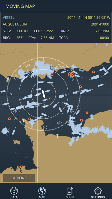
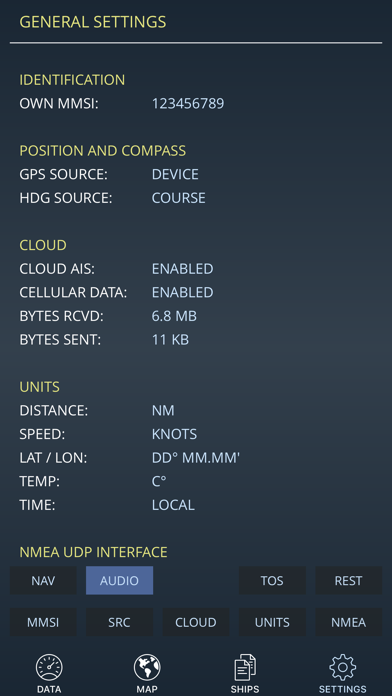
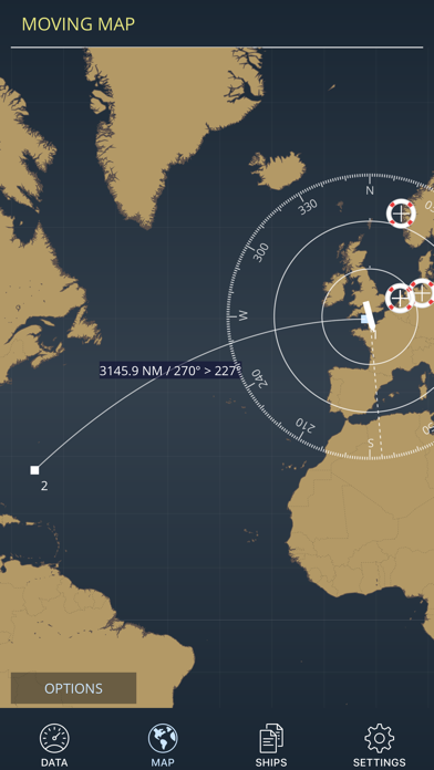
OceanTrack is the ultimate marine navigation app for iOS, providing real time instrument reading, AIS traffic and passage information. With worldwide built-in map coverage, the ocean is the limit. Traffic awareness features allow you to stay safe and sail safely whether you're entering a busy shipping lane or sailing in the middle of the Pacific without Internet connectivity.
Developed and tested on a real sailing vessel, OceanTrack makes use of a combination of the device's internal GPS and Compass sensors to provide instant data on current position, speed over ground, course and heading, plotted on a stylish navigation Display.
With Cloud AIS, providing you have Internet connectivity …
Read the full description
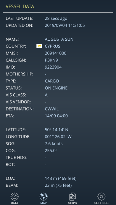
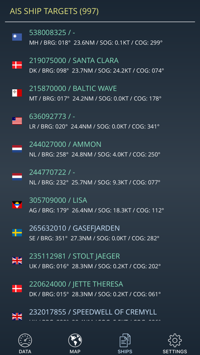
OceanTrack is the ultimate marine navigation app for iOS, providing real time instrument reading, AIS traffic and passage information. With worldwide built-in map coverage, the ocean is the limit. Traffic awareness features allow you to stay safe and sail safely whether you're entering a busy shipping lane or sailing in the middle of the Pacific without Internet connectivity. Developed and tested on a real sailing vessel, OceanTrack makes use of a combination of the device's internal GPS and Compass sensors to provide instant data on current position, speed over ground, course and heading, plotted on a stylish navigation Display. With Cloud AIS, providing you have Internet connectivity and there is land AIS coverage, OceanTrack comes with complimentary AIS information data with thousands of ships sailing around the world at any given moment. See ships anywhere and tap on them to discover who they are, how far they are or where they're going. Through NMEA, OceanTrack can also connect to your boat's systems via an NMEA-to-WiFi bridge / server, collect real-time data from multiple onboard sensors, AIS receivers, and display accurate information on position, boat speed, depth below keel, wind speed and direction and surrounding marine traffic amongst other things. OceanTrack includes an advanced Multi Function Display and Map (MFD) with: - GPS Position Information - Speed Over Ground, Course Over Ground, Heading - Speed over Water, Depth Below Keel - Apparent and True Wind Speed and Direction - Beaufort Scale Estimation on screen - DTW, BTW, XTE and VMG when next waypoint is available - Dynamic zoomable range - Built-in moving map for use when offline and offshore; the whole world is included, no need to download it - Support for AIS-SART, AIS-MOB and AIS-EPIRB devices, plotting Man Overboard (MOB) positions on screen with relative bearing, distance and time to reach - a life saver! - Plotting of AIS targets including ships, navigation aids, shore stations and Search and Rescue (SAR) aircrafts - On-Map measurement of range, bearing and ETE at current speed to any point - Quick multi-hop tap-hold-and-drag route planning anywhere in the world - AIS info including Name, MMSI, SOG, COG, RNG, BRG - AIS directed and broadcast messages display and alerts - Advanced calculation of CPA and TCPA to any AIS ship - Selection of rhumb-line (loxodromic) or great-circle (orthodromic) navigation - Mercator Projection - Various unit selections and display formats - Portrait and Landscape orientations on iPad access to onboard instruments with: - An NMEA decoder to interface with onboard AIS receivers - NMEA on TCP and UDP interfaces - NMEA support for VDM, RMC, GSA, GSV, GLL, VTG, GGA, HDT, HDG, VHW, DBT, DPT, MWV, MTW and RMB sentences and an AIS engine with: - List of all surrounding AIS vessels sorted by distance - Detailed AIS information on vessels including all static and dynamic performance indicators (MMSI, position, SOG, COG, country, dimensions, ...) Requirements: OceanTrack is iOS only and universal for any iPad, iPhone and iPod touch running iOS 9.0 or later. To access onboard instruments and surrounding AIS traffic (other than cloud AIS which has limited coverage and requires Internet connectivity), OceanTrack requires a WiFi network, an NMEA to WiFi server and the NMEA Connector inApp purchase. Most modern plotters provide this bridging and WiFi funcionality nowadays but should they not, NMEA to WiFi adapters can usually be installed separately to provide access.
Installs
Apple does not publish download counts. Estimates are in testing.
We publish iOS estimates only after they pass a back-test against real numbers. Chart history below is measured.
Estimated store revenue Estimated Beta
App Store, worldwide, monthly rate from the last 14 chart days to 21 Nov 2026
Below the top 100 grossing apps in the markets we calibrate. In the United States that usually means under about $6.4M a month. App Store purchases and subscriptions only, before Apple's 15 to 30% fee. Ads and web payments are not included.
Ratings
No rating breakdown published for this app.
Recent reviews
Latest public reviews from the store
No reviews in our sample for this app yet.
Top chart positions
Latest App Store chart ranks by country, last 10 days
Not in any tracked top chart in the last 10 days.
OceanTrack history
Release, install milestones, listing and store changes
- First released on the store 22 Apr 2018
Update frequency
How often OceanTrack ships a new version, month by month
0 updates in the last 12 months. Less often than most similar apps: they shipped a median of 1 updates in the same year.
Recent versions
Current version 1.4.4
- Version 1.4.418 Oct 2020
Includes iOS 14 and hardware support improvements.
Listing keywords
Words and phrases OceanTrack repeats most in its store listing
Top phrases: nmea to wifi (3), internet connectivity (3), depth below keel (2), speed and direction (2), speed over ground (2).
Highlighted words also appear in the title. Counts cover the title, short description and description.
Compliance
What the listing and the app package show
- Store status
- Live
- Upkeep
- No update since 18 Oct 2020
- Age rating
- 4+
Apps like OceanTrack
 Canals.UKMARK MANSER★ 4.74
 Chevron Car WashDigital Mosaic Corporation★ 1.62
 hitta.sehittapunktse AB★ 4.6
 NextStop - NYC SubwayPliable Matter LLC★ 3.74
 E-Charge HKHong Kong EV Power Limited★ 4.34
 Simply NorthBusyBytes GmbH★ 4.08
 Doyle GuidesChris Doyle Publishing Limited★ 4.32
 Speedometer Speed MPH TrackerRihab Mehboob★ 4.62
 Property Line Finder - ParcelHealth & Wellness Apps Limited★ 4.28
OceanTrack: questions and answers
Who makes OceanTrack?
OceanTrack is published by Joao Cabral.
When was OceanTrack last updated?
The latest version (1.4.4) was released on 18 Oct 2020.
Is OceanTrack free?
Yes. OceanTrack is free to download.
Is OceanTrack still available?
Yes. OceanTrack is live on App Store as of 10 May 2026.
Track OceanTrack and its competitors
Watch any app for new versions, rating drops, chart moves and removals. Free plan, no card.