
- Installs
- —
- Apple does not publish download counts
- Rating
- 4.0
- Ratings
- 2
- Version
- 2.0
- Updated 22 Jul 2026
- Released
- 17 Dec 2014
- Tracked since 2 Jun 2026
- Size
- 16 MB
- Needs 26.0
Screenshots


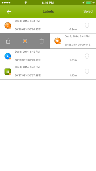
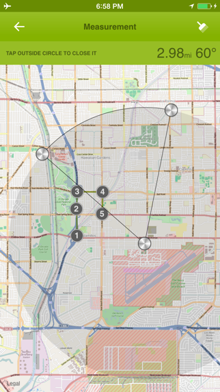
About Offline Maps - GPS Tracker
The description on the store listing
Offline Maps is a practical map companion for travel, hiking, cycling, field work, and any day when you want your map tools ready before the signal disappears.
Open the app and start working directly on the map. Choose from Apple maps, OSM vector maps, OSM legacy maps, cycling, hiking, nautical, aeronautical, and other supported sources. Save map areas for offline use where downloads are supported, then keep exploring with your tracks, waypoints, measurements, and coordinate tools in one clean workspace.
Record GPS tracks, pause and resume when needed, and keep an eye on your progress with live distance and speed statistics. Saved tracks can be searched, renamed, shown on the map, styled …
Read the full description
Offline Maps is a practical map companion for travel, hiking, cycling, field work, and any day when you want your map tools ready before the signal disappears. Open the app and start working directly on the map. Choose from Apple maps, OSM vector maps, OSM legacy maps, cycling, hiking, nautical, aeronautical, and other supported sources. Save map areas for offline use where downloads are supported, then keep exploring with your tracks, waypoints, measurements, and coordinate tools in one clean workspace. Record GPS tracks, pause and resume when needed, and keep an eye on your progress with live distance and speed statistics. Saved tracks can be searched, renamed, shown on the map, styled with solid colors or gradients, imported from common GPS formats, and exported when you need to share your route. Mark important places with waypoints, customize icons, rename them, search your waypoint list, and use waypoint tracking to see distance labels and guide lines on the map. Long-press the map or use your current position to create a new waypoint in seconds. Measure what matters in the field: lines, polylines, radius, circles, rectangles, and polygons. Drag points to adjust shapes, save measurements as map items, and export selected data when the job is done. Offline Maps also includes coordinate tools for Decimal, DMS, UTM, MGRS, Plus Code, and GeoHash formats. Copy or share individual coordinate values, open Google Maps links, and quickly search by pasted coordinates or map links. Built for modern iPhone and iPad, Offline Maps keeps the map at the center and places tracks, waypoints, and measurements together in Map Items so your important data stays easy to find. Key Features - Save supported map areas for offline use. - Browse multiple map sources, including Apple, OSM vector, OSM legacy, cycling, hiking, nautical, and aeronautical maps. - Record GPS tracks with pause, resume, background recording, recovery, and Live Activity support. - Import and export GPX, KML, KMZ, GeoJSON, TCX, and CSV track data. - Export track map images as PNG files. - Add, rename, search, show, hide, import, and export waypoints. - Track waypoint distances with guide lines and compact labels on the map. - Measure distances, radius, circles, rectangles, and polygon areas. - Manage tracks, waypoints, and measurements together in Map Items. - Work with Decimal, DMS, UTM, MGRS, Plus Code, and GeoHash coordinates. - Copy, share, and search coordinates, including supported Google Maps links. - Choose measurement units: metric, imperial, or nautical. - Keep the screen awake during navigation when needed. If you know more map sources please write us: [email protected]
Installs
Apple does not publish download counts. Estimates are in testing.
We publish iOS estimates only after they pass a back-test against real numbers. Chart history below is measured.
Estimated store revenue Estimated Beta
App Store, worldwide, monthly rate from the last 12 chart days to 19 Nov 2026
Below the top 100 grossing apps in the markets we calibrate. In the United States that usually means under about $6.4M a month. App Store purchases and subscriptions only, before Apple's 15 to 30% fee. Ads and web payments are not included.
Ratings
2 ratings
No rating breakdown published for this app.
Recent reviews
Latest public reviews from the store
No reviews in our sample for this app yet.
Top chart positions
Latest App Store chart ranks by country, last 10 days
Not in any tracked top chart in the last 10 days.
Offline Maps - GPS Tracker history
Release, install milestones, listing and store changes
- First released on the store 17 Dec 2014
Update frequency
How often Offline Maps - GPS Tracker ships a new version, month by month
1 updates in the last 12 months. About as often as similar apps, which shipped a median of 1 updates in the same year.
Recent versions
Current version 2.0
- Version 2.022 Jul 2026
+ Added a new map-first workspace with modern floating controls. + Added grouped map providers for Apple, OSM, Google viewing, cycling, hiking, nautical, other maps, and FAA chart layers. + Added OSM Vector/OpenFreeMap support through vector map rendering. + Added offline area downloads for supported providers with progress, retry, resume, rename, delete, update, thumbnails, and provider-specific saved-area overlays. + Added a one-time 500 MB offline storage reward after the first successful offline map download. + Added GPS track recording with pause, resume, stop confirmation, background recording, recovery, Live Activity support, and live map drawing. + Added track search, track thumbnails, selected-track display on the map, color and gradient styles, and start/end markers. + Added track import and export for GPX, KML, KMZ, GeoJSON, TCX, and CSV, plus PNG map image sharing. + Added Map Items, a single place to manage tracks, waypoints, and measurements. + Added waypoint creation from current location, long-press, selected coordinates, and GPX import. + Added waypoint icons, renaming, search, show/hide controls, coordinate sharing, and GPX export. + Added waypoint tracking mode with distance labels and guide lines to visible and offscreen waypoints. + Added measurement tools for lines, polylines, radius, circles, rectangles, and polygons with draggable points. + Added measurement import/export for GeoJSON, KML, GPX, and CSV. + Added coordinate inspection and coordinate search for Decimal, DMS, UTM, MGRS, Plus Code, GeoHash, and supported Google Maps links. + Added Settings options for offline maps, measurement units, sleep prevention, support contact, and app information.
Listing keywords
Words and phrases Offline Maps - GPS Tracker repeats most in its store listing
Top phrases: offline maps (4), map items (3), tracks waypoints (3), areas for offline (2), code and geohash (2).
Highlighted words also appear in the title. Counts cover the title, short description and description.
Compliance
What the listing and the app package show
- Store status
- Live
- Upkeep
- Updated 22 Jul 2026
- Registered in
- France
- Age rating
- 4+
Apps like Offline Maps - GPS Tracker
 Canals.UKMARK MANSER★ 4.74
 Chevron Car WashDigital Mosaic Corporation★ 1.62
 hitta.sehittapunktse AB★ 4.6
 NextStop - NYC SubwayPliable Matter LLC★ 3.74
 E-Charge HKHong Kong EV Power Limited★ 4.34
 Simply NorthBusyBytes GmbH★ 4.08
 Doyle GuidesChris Doyle Publishing Limited★ 4.32
 Speedometer Speed MPH TrackerRihab Mehboob★ 4.62
 Property Line Finder - ParcelHealth & Wellness Apps Limited★ 4.28
Offline Maps - GPS Tracker: questions and answers
Who makes Offline Maps - GPS Tracker?
Offline Maps - GPS Tracker is published by Sergey Vdovenko, a developer based in FR.
When was Offline Maps - GPS Tracker last updated?
The latest version (2.0) was released on 22 Jul 2026.
Is Offline Maps - GPS Tracker free?
No. Offline Maps - GPS Tracker is a paid app priced at $2.99.
Is Offline Maps - GPS Tracker still available?
Yes. Offline Maps - GPS Tracker is live on App Store as of 23 Jul 2026.
Track Offline Maps - GPS Tracker and its competitors
Watch any app for new versions, rating drops, chart moves and removals. Free plan, no card.