
Air Navigation Pro
Fly safely and easily with our flight planning & real time navigation app!
- Installs
- 527K
- Measured
- Rating
- 3.71
- Ratings
- 5.2K
- 156 reviews
- Version
- 8.5.4.611100758
- Updated 30 Oct 2026
- Released
- 28 Mar 2012
- Tracked since 13 May 2026
- Size
- —
Also on App Store: Air Navigation Pro (646 ratings)
Screenshots

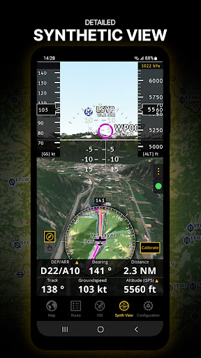
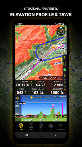
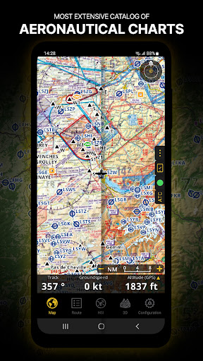
About Air Navigation Pro
The description on the store listing
Discover our flight planning & real-time navigation app for free for 28 days!
- Everything you need to fly around the world
- Plan your flight in a few minutes
- Fly relaxed with up-to-date information
Air Navigation Pro is a high-quality flight assistant app for pilots worldwide. Benefit from the following main features:
MOVING MAP
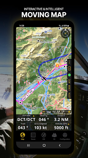
Plan and navigate using our interactive moving map. Choose between aeronautical charts, satellite or our vector map as a background. On top of that, the moving map displays waypoints, NOTAM, obstacles and airspaces from our comprehensive, always up-to-date worldwide aeronautical database. Tap on any waypoint directly on the map to easily create a …
Read the full description
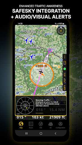
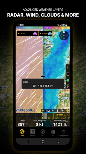
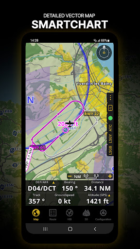
Discover our flight planning & real-time navigation app for free for 28 days! - Everything you need to fly around the world - Plan your flight in a few minutes - Fly relaxed with up-to-date information Air Navigation Pro is a high-quality flight assistant app for pilots worldwide. Benefit from the following main features: MOVING MAP Plan and navigate using our interactive moving map. Choose between aeronautical charts, satellite or our vector map as a background. On top of that, the moving map displays waypoints, NOTAM, obstacles and airspaces from our comprehensive, always up-to-date worldwide aeronautical database. Tap on any waypoint directly on the map to easily create a route. Personalize the values shown on the navbar to have exactly the information you need: altitude, vertical speed, bearing, distance to the next waypoint, ETA calculations, etc. Choose the airport departure and arrival procedures for your route to have them also displayed on top of the moving map. ENHANCED TRAFFIC AWARENESS Get visual and audio alerts in all languages for nearby conflicting traffic. Choose your preferred traffic icon between generic, aircraft or TCAS symbols. Your safety is important to us, which is why we partnered with SafeSky to ensure our users have live traffic data during their flight. Benefit from the native integration with SafeSky included in our new Smart Lite, Smart Classic and Smart Advanced subscriptions—a two-in-one package! ADVANCED WEATHER LAYERS In addition to the basic weather reports of winds and TAF/METAR for your flight, subscribers of the Smart Advanced plan can activate see-through weather layers on top of the moving map. Available layers include rain radar, wind, pressure, clouds and rain, visibility, gust and additionally for Germany, Switzerland, Austria and the Balkans, GAFOR reports. Tap on any point on the map to see the weather information for that area. Review the weather forecast for up to three days ahead. NOTAM After creating your route, set the departure time in the future to have the moving map display the NOTAM active for that specific time. NOTAM on the map change color dynamically based on their status. SMARTCHART Our cutting-edge SmartChart is a highly detailed and intelligent vector-based map that adapts to your needs, providing you with adequate information at any zoom level. The SmartChart optimizes the display of shadows to easily distinguish between valleys and mountains, and the text remains perfectly aligned, guaranteeing optimal readability. Including the latest significant improvements with forests and detailed airport information. ELEVATION PROFILE & SYNTHETIC VIEW Enable the profile view below the navbar for enhanced situational awareness of the elevation ahead of you or along your route. Choose the corridor width between 0 to 5 NM and overlay options: airspaces, NOTAM, obstacles, wind components, populated places, etc. Switch to the synthetic view for additional terrain information, plus an artificial horizon with altitude and vertical speed indicators. This function can also be used to pan around while preparing for your flight. Activate TAWS on the moving map as well as on the synthetic view. AERONAUTICAL CHARTS & APPROACH CHARTS We offer the most extensive worldwide catalog of aeronautical charts, including the ICAO charts. Have the georeferenced approach charts displayed on top of the moving map or the synthetic view. BRIEFING Prepare your flight with our briefing section by creating documents with NOTAM and weather charts & stations relevant to your planned route. Optimize time by creating an aircraft profile which will be used in the Briefing section to pre-fill for you the ATC Flight Plan and calculate the W&B. AND SO MUCH MORE! A subscription allows you to use the app on three devices. We recommend creating an Air Navigation account for improved device management. Refer to our user manual on our website: www.airnavigation.aero for more information.
Installs, last 30 days Measured
Exact Google Play install counts, collected daily
Ratings
5,194 ratings, 156 reviews
- 5 ★57%
- 4 ★11%
- 3 ★4.5%
- 2 ★1.0%
- 1 ★27%
Recent reviews
Latest public reviews from the store
- 10 Feb 2025
It helps with everything from learning to productivity. The responses are quick and accurate. It will surely helps to students and professionals to enhance their ingenuity.
- 8 Feb 2025
User friendly interface, easy to access and yet creative. Definitely a good platform for interacting with professionals as well as learning enthusiasts.
- 8 Feb 2025
Superb experience with AI, smooth UI interface. Overall good experience with all app features.
- 4 Dec 2024
Best apps for job searching and for professional updates.
What reviewers bring up
Topics mentioned in the latest 6 reviews, by how many reviews mention them
Liked in good reviews (6 reviews)
- professionals 3
- experience 2
- interface 2
- learning 2
- students 2
- features 2
- overall 2
Raised in bad reviews (0 reviews)
No topic comes up twice.
Top chart positions
Latest Google Play chart ranks by country, last 10 days
Not in any tracked top chart in the last 10 days.
Air Navigation Pro history
Release, install milestones, listing and store changes
- Reached 500,000+ installs 31 Mar 2026
- Reached 100,000+ installs 6 Feb 2021
- First released on the store 28 Mar 2012
Update frequency
How often Air Navigation Pro ships a new version, month by month
8 updates in the last 12 months. More often than most similar apps: they shipped a median of 2 updates in the same year.
Recent versions
Current version 8.5.4.611100758
- Version 8.4.171.60717083517 Jul 2026
New in 8.4.170: choose local or UTC (Zulu) time across the app, clearer restricted areas/NOTAMs, Locked North-Up orientation, customizable flight trace width, expanded sunrise/sunset options, user waypoint take-offs/landings, post-flight Scratchpad notes for logbook records, improved Manager device settings, and added export fields.
- Version 8.4.170.60625115325 Jun 2026
New in 8.4.170: choose local or UTC (Zulu) time across the app, clearer restricted areas/NOTAMs, Locked North-Up orientation, customizable flight trace width, expanded sunrise/sunset options, user waypoint take-offs/landings, post-flight Scratchpad notes for logbook records, improved Manager device settings, and added export fields.
- Version 8.4.163.6040904238 Apr 2026
• New map styles: ONC and British • OpenStreetMap can now be used as an online map background • Added MGRS grid display • Route creation now supports JeppView syntax • Additional public-domain airfields added • Improved contrast for Nature Reserves • More accurate ETE/ETA computation • Improved flight tracking • User points can now be filtered by manager tag • Import/export of user points (including manager tag) • Option to hide point names in KML documents
- Version 8.4.162.60318215418 Mar 2026
Listing keywords
Words and phrases Air Navigation Pro repeats most in its store listing
Top phrases: moving map (8), synthetic view (4), aeronautical charts (3), air navigation (3), air navigation pro (2).
Highlighted words also appear in the title. Counts cover the title, short description and description.
Business model and tech
From the store listing, the SDKs in the app package and its declared permissions
- Business model
- Free to downloadIn-app purchases
- Built with
- No cross-platform framework or game engine detected
- Ad networks (0)
- None detected
- Subscriptions and payments
- Google Play billing
- Analytics and crash reports
- Firebase
- Sign-in and social
- Sensitive access
- LocationCameraPhotos, videos and filesAccounts on the deviceNearby devicesAdvertising ID
1 ad, attribution and analytics SDKs detected. SDKs are read from the app package and permissions from the store listing, so code that loads later is not seen.
Technology
37 SDKs found in the app package
29 permissions
0 special access, 9 sensitive, 20 standard
- Take photos and videosSensitive
- See accounts on the deviceSensitive
- Change or delete shared storageSensitive
- Read shared storageSensitive
- Approximate locationSensitive
- Location in the backgroundACCESS_BACKGROUND_LOCATIONSensitive
- Precise locationSensitive
- Connect to paired Bluetooth devicesBLUETOOTH_CONNECTSensitive
- Find nearby Bluetooth devicesBLUETOOTH_SCANSensitive
- Ad attribution (Privacy Sandbox)ACCESS_ADSERVICES_ATTRIBUTIONStandard
- Ad topics (Privacy Sandbox)ACCESS_ADSERVICES_TOPICSStandard
- Privacy Sandbox ads (custom audience)ACCESS_ADSERVICES_CUSTOM_AUDIENCEStandard
Compliance
What the listing and the app package show
- Store status
- Live
- Upkeep
- Updated 30 Oct 2026
- Registered in
- Switzerland
- Privacy policy
- Linked on the listing
- Advertising
- No ads declared
- In-app purchases
- Offered
- Age rating
- Everyone
- Sensitive permissions
- 9 sensitive of 29
- Location access
- Yes, also in the background
- Camera and microphone
- Camera
Apps like Air Navigation Pro
UNE Transporte SonoraGobierno del Estado Sonora1.3M installs★ 3.61
STAR : bus, métro à RennesKeolis Rennes Métropole397K installs★ 4.38
Va-y-VenGobierno Digital Yucatán1.1M installs★ 3.39
AR GPS DRIVE/WALK NAVIGATIONwalter hsieh1.4M installs★ 3.46
Rutas Transmilenio y SITPTuxerito910K installs★ 3.0
Barik NFCCTB - Consorcio de Transportes de Bizkaia566K installs★ 4.33
Esso and Mobil™ AppExxonMobil817K installs★ 3.0
Snapper MobileSnapper Services273K installs★ 4.1
Parked Car LocatorNewLook508K installs★ 4.42
Air Navigation Pro: questions and answers
How many downloads does Air Navigation Pro have?
Air Navigation Pro has 527,146 installs on Google Play, measured from the store's own count on 19 Nov 2026.
Who makes Air Navigation Pro?
Air Navigation Pro is published by Air Navigation SA, a developer based in CH.
When was Air Navigation Pro last updated?
The latest version (8.5.4.611100758) was released on 30 Oct 2026.
Is Air Navigation Pro free?
Yes. Air Navigation Pro is free to download and offers in-app purchases.
Is Air Navigation Pro still available?
Yes. Air Navigation Pro is live on Google Play as of 19 Nov 2026.
Track Air Navigation Pro and its competitors
Watch any app for new versions, rating drops, chart moves and removals. Free plan, no card.