
登山地図
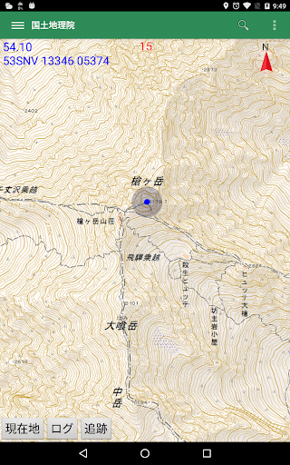
It is an application that displays the map of the Geographical Survey Institute. If you save the map, you can view it offline. There is a track log function. Convenient for mountaineering, hiking, trekking and fishing.
- Installs
- 97.04K
- Measured
- Rating
- —
- Ratings
- —
- Version
- Varies with device
- Updated 20 Apr 2026
- Released
- —
- Tracked since 13 May 2026
- Size
- —
Screenshots


About 登山地図
The description on the store listing
With this app, you can check your current location on the map (Geographical Survey Institute map) by saving the map in advance even in places where radio waves do not reach.
You can reduce the risk of getting lost by climbing or hiking. You can also save the walking track as a gps file.
■ You can check your current location on the map
Simply tap the "You are here" button at the bottom of the screen and the red mark of your current location will be displayed on the map. Since the GPS function of the terminal is used,
GPS function must be turned on. In addition, you can save the location information of your current location as a registered location with the touch of a button.
.
* …
Read the full description
With this app, you can check your current location on the map (Geographical Survey Institute map) by saving the map in advance even in places where radio waves do not reach. You can reduce the risk of getting lost by climbing or hiking. You can also save the walking track as a gps file. ■ You can check your current location on the map Simply tap the "You are here" button at the bottom of the screen and the red mark of your current location will be displayed on the map. Since the GPS function of the terminal is used, GPS function must be turned on. In addition, you can save the location information of your current location as a registered location with the touch of a button. . * Note: This app does not collect location information. The use of location information is the following functions only within this app. (1) Display your current location on a map. (2) Track log recording. ■ Track log (walking track, hereafter log) can be saved With the background function, this app can log even if you are using other apps. When saving is completed, Save it in the app as a GPX fal. * Note: Even if the app is closed, it is recorded in the background, so start the app again and start it again. Keep recording until you are finished. ■ Maps can be displayed even outside the service area If you save the map in advance, you can display the map even if you are out of service or offline. You can save Only the map of the Geographical Survey Institute. There is no limit to the range that can be saved at one time. . ■ Can display GPX files You can read the GPX file downloaded from Yamareco etc. and display the trajectory on the map. You can walk while checking your current location and trajectory. You can reduce the risk of getting lost by climbing or hiking. ■ You can register the location You can register the position you want to remember and display it on the map. You can register up to 1000 locations. ■ Distance can be measured If you select distance measurement from the menu, you can measure the distance by simply tapping on the screen. . ■ Precautions for use If you use it for mountain climbing, please bring a map, compass and spare battery just in case. In addition, this author is not responsible for any loss or damage such as distress caused by using this application. ■ Inquiries Service: https://gacool.jp Email: [email protected]
Installs Measured
Exact Google Play install counts, collected daily
Daily history starts once this app is in our daily install sample.
Ratings
- 5 ★0.0%
- 4 ★0.0%
- 3 ★0.0%
- 2 ★0.0%
- 1 ★0.0%
Recent reviews
Latest public reviews from the store
No reviews in our sample for this app yet.
Top chart positions
Latest Google Play chart ranks by country, last 10 days
Not in any tracked top chart in the last 10 days.
登山地図 history
Release, install milestones, listing and store changes
- Moved from Travel & Local to Sports 24 Feb 2026
Update frequency
How often 登山地図 ships a new version, month by month
3 updates in the last 12 months. More often than most similar apps: they shipped a median of 0 updates in the same year.
Recent versions
Current version Varies with device
- Version 10.5.720 Apr 2026
- Version 10.4.829 Mar 2026
- Version 10.4.78 Feb 2026
- Version 10.4.221 Oct 2025
Listing keywords
Words and phrases 登山地図 repeats most in its store listing
Top phrases: current location (6), geographical survey institute (3), geographical survey (3), location information (3), survey institute (3).
Highlighted words also appear in the title. Counts cover the title, short description and description.
Business model and tech
From the store listing, the SDKs in the app package and its declared permissions
- Business model
- Free to downloadIn-app purchasesShows ads
- Built with
- No cross-platform framework or game engine detected
- Ad networks (0)
- None detected
- Subscriptions and payments
- Google Play billing
- Sensitive access
- LocationCameraPhotos, videos and filesAdvertising ID
0 ad, attribution and analytics SDKs detected. SDKs are read from the app package and permissions from the store listing, so code that loads later is not seen.
Technology
5 SDKs found in the app package
Development tools
18 permissions
0 special access, 9 sensitive, 9 standard
- Take photos and videosSensitive
- Change or delete shared storageSensitive
- Read photosREAD_MEDIA_IMAGESSensitive
- Read shared storageSensitive
- Read videosREAD_MEDIA_VIDEOSensitive
- Approximate locationSensitive
- Location in the backgroundACCESS_BACKGROUND_LOCATIONSensitive
- Precise locationSensitive
- Show notificationsPOST_NOTIFICATIONSSensitive
- Read the advertising IDAD_IDStandard
- Control vibrationStandard
- Foreground service (location)FOREGROUND_SERVICE_LOCATIONStandard
Compliance
What the listing and the app package show
- Store status
- Live
- Upkeep
- Updated 20 Apr 2026
- Registered in
- Japan
- Privacy policy
- Linked on the listing
- Advertising
- Shows ads
- In-app purchases
- None declared
- Age rating
- Everyone
- Sensitive permissions
- 9 sensitive of 18
- Location access
- Yes, also in the background
- Camera and microphone
- Camera
Apps like 登山地図
데일리피싱 - 낚시금지구역, 조과, 물때, 낚시, 낚금데일리피싱55.8K installs★ 4.4
Team USA Mobile CoachUnited States Olympic & Paralympic Committee13.6K installs★ 3.93
The trails of central AbruzzoArchimede - A.S.I. srl9.6K installs★ 3.6
SquashSkills CoachingSquashSkills4.4K installs★ 5.0
Rally Control AppMarcin Jankiewicz10K installs★ 4.8
TV Aldekerk HandballAndreas Gigli2.1K installs★ 4.8
Pikel: Pickleball & DUPR SyncPlyvo Apps740 installs★ 4.9
8 Ball Pool BilliardPuzzleGamesArt12K installs★ 4.0
Soccer World Cup 2026LeetRCE Labs43.5K installs★ 3.2
登山地図: questions and answers
How many downloads does 登山地図 have?
登山地図 has 97,036 installs on Google Play, measured from the store's own count on 13 May 2026.
Who makes 登山地図?
登山地図 is published by gacool, a developer based in JP.
When was 登山地図 last updated?
The latest version (Varies with device) was released on 20 Apr 2026.
Is 登山地図 free?
Yes. 登山地図 is free to download, and it shows ads.
Is 登山地図 still available?
Yes. 登山地図 is live on Google Play as of 13 May 2026.
Track 登山地図 and its competitors
Watch any app for new versions, rating drops, chart moves and removals. Free plan, no card.