
國道一路通 - 高速公路即時路況圖及即時影像
Open the location, which is the car condition map near the center of the location on the actual map, and the map can be zoomed to quickly understand the highway condition. It also provides functions such as front vehicle speed, speed camera detection, real-time monitor image, police radio station, and voice broadcast along the route.
- Installs
- 62.14K
- Measured
- Rating
- —
- Ratings
- —
- Version
- 4.1.6
- Updated 29 Sep 2026
- Released
- 17 Feb 2017
- Tracked since 14 May 2026
- Size
- 42 MB
- Needs 6.0
Screenshots



About 國道一路通 - 高速公路即時路況圖及即時影像
The description on the store listing
National highway all the way - real-time images of Taiwan's highways, traffic jam conditions, speed inquiries and voice broadcasts along the route
Open the positioning and draw the traffic conditions near the center of the location on the actual map. You can zoom in and out of the map. It is no longer a small zoom-out map, and you can instantly understand the traffic conditions on the highway. It also provides functions such as vehicle speed between highway interchanges in various countries, speed camera detection, real-time monitor images, police radio stations, and voice broadcasts along the route.
Currently it includes road sections: national highways, expressways (Province 6x, …
Read the full description
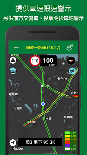
National highway all the way - real-time images of Taiwan's highways, traffic jam conditions, speed inquiries and voice broadcasts along the route Open the positioning and draw the traffic conditions near the center of the location on the actual map. You can zoom in and out of the map. It is no longer a small zoom-out map, and you can instantly understand the traffic conditions on the highway. It also provides functions such as vehicle speed between highway interchanges in various countries, speed camera detection, real-time monitor images, police radio stations, and voice broadcasts along the route. Currently it includes road sections: national highways, expressways (Province 6x, Provincial 7x, Provincial 8x, etc.) and the Provincial Highway 9 section from Suao to Fenggang (three sections of Suhua Gai, Huadong and Nanhui) The main function - Ready to use: Open the positioning and draw the vehicle condition map near the center of the location on the actual map, and the real national road conditions will be communicated in real time. - Basemap selection: The map uses Mapbox, providing "white basemap" and "black basemap". - Map zoom: You can zoom in to see which section of the road is blocked by the interchange. When it is reopened, it will be zoomed according to the last viewing ratio. - Nearby highways: The homepage list lists the national highways and expressways of the nearest interchanges according to the positioning coordinates, making it easy to find the nearest national highways - Vehicle speed information: Provides vehicle speed information between highway interchanges in various countries - Police radio station: Play police radio station option settings, the default is to switch to the nearest regional police radio station based on the location, and you can switch to the nationwide network option. - Surveillance images: Provide real-time CCTV images between road intersections in various countries - Power-saving positioning: In addition to the initial positioning, it will be repositioned every five minutes, and the map center location will be updated according to the coordinates. - Road signs: National highways and expressway signs are marked on the map (excluding National 1 and National 3 signs). You can switch to indicate the location of police traffic information. - Speed warning: It also provides "alongside information and speed" mode switching. In addition to the above basic voice broadcast, it also includes a speed measurement function. If the speed limit is exceeded, the speed will be reminded in red letters. If the speed limit is exceeded (110%, 105 %, 100%), a beep sound will sound. This function can also be turned off. Due to continuous positioning, the basic voice broadcast function will be more accurate. However, the power consumption is relatively high. It is recommended to connect the power supply (such as a portable battery, etc.) at the same time for use. In addition, in this mode, the map will automatically turn to the direction of the car. - Other broadcasts: You can also set the average speed broadcast of the intersection ahead and the road section ahead. - Interchange points: Interchanges are marked with dotted hollow circles on the map. Click to view the name of the interchange to facilitate the identification of traffic jams (to avoid confusion with National 1, excluding the "Xiwu Elevated" interchange) - Voice broadcast: Provide information broadcast along the route, including electronic signboards (also known as information display boards, CMS) along the route, fixed speed cameras, rest service areas and police broadcasts for real-time traffic conditions. Supports background voice broadcast function and can be used with other foreground navigation software (such as Google Map). *Notes on voice broadcasting - When the voice broadcast is turned on, the positioning will be changed from the original five-minute power-saving positioning to the one-minute positioning, which will consume more power. - The same content will not be broadcast repeatedly within a short period of time. - To avoid confusion with Country 1, the broadcast content does not include the "Xiwu Elevated" interchange information. - Since the positioning is only done once per minute, some road sections that are close to parallel may be misjudged, such as the sections of National Highway 1 that are close to Provincial Highway 72 and Provincial Highway 74 respectively. - If the program determines that you are not on a national highway or expressway within fifteen minutes, it will automatically stop the voice broadcast to save power. - If you feel that the voice broadcast is too quiet compared to other music sounds, please go to the phone's settings and follow the steps below to increase the voice volume: Language and input settings >> Text-to-speech output >> Google text-to-speech engine (settings on the right) Illustration) >> Google text-to-speech engine settings >> Increase voice volume. Image description: https://goo.gl/BL5LQf Main sources of information: - Ministry of Transport, National Highways and Expressway Bureau 1968 Road Conditions "Traffic Database" - Information on roadside equipment for provincial highway traffic control from the Highway Administration of the Ministry of Transport -Police Department real-time traffic information If you have other functional requirements or have problems with use, you can use the App settings to report it to us. In addition, there are many sources of data, and it is inevitable that there will be errors in the data. You can also use the app settings to report it to us.
Installs since 31 Aug 2026 Measured
Exact Google Play install counts, collected daily
Ratings
- 5 ★0.0%
- 4 ★0.0%
- 3 ★0.0%
- 2 ★0.0%
- 1 ★0.0%
Recent reviews
Latest public reviews from the store
- 4 Feb 2023
Nice
- 9 Jun 2022
Exceptional
- 28 Jan 2022
Great product.
- 8 Jun 2020
Very easy to use.
What reviewers bring up
Topics mentioned in the latest 10 reviews, by how many reviews mention them
Liked in good reviews (5 reviews)
No topic comes up twice.
Raised in bad reviews (5 reviews)
- bluetooth 2
- connect 2
- find 2
Top chart positions
Latest Google Play chart ranks by country, last 10 days
Not in any tracked top chart in the last 10 days.
國道一路通 - 高速公路即時路況圖及即時影像 history
Release, install milestones, listing and store changes
- Reached 50,000+ installs 23 Feb 2025
- Reached 10,000+ installs 19 Apr 2018
- Reached 5,000+ installs 9 Dec 2017
- Reached 1,000+ installs 13 Apr 2017
- Reached 500+ installs 22 Mar 2017
- Reached 100+ installs 23 Feb 2017
- First released on the store 17 Feb 2017
Update frequency
How often 國道一路通 - 高速公路即時路況圖及即時影像 ships a new version, month by month
3 updates in the last 12 months. More often than most similar apps: they shipped a median of 1 updates in the same year.
Recent versions
Current version 4.1.6
- Version 4.1.629 Sep 2026
新增國5 可切換成單一車速,或者分車道呈現
- Version 4.1.331 Jul 2026
改善背景語音播報服務與通知權限穩定度
- Version 4.0.012 Jan 2026
1. 更新改善一些運作模組 2. 新增變更字體大小按鈕
- Version 3.5.1a29 Mar 2021
Listing keywords
Words and phrases 國道一路通 - 高速公路即時路況圖及即時影像 repeats most in its store listing
Top phrases: voice broadcast (8), along the route (5), national highways (5), police radio (5), police radio station (4).
Highlighted words also appear in the title. Counts cover the title, short description and description.
Business model and tech
From the store listing and declared permissions
- Business model
- Free to downloadShows ads
- Sensitive access
- No sensitive permission declared
Compliance
What the listing and the app package show
- Store status
- Live
- Upkeep
- Updated 29 Sep 2026
- Registered in
- Taiwan
- Privacy policy
- Linked on the listing
- Advertising
- Shows ads
- In-app purchases
- None declared
- Age rating
- Everyone
Apps like 國道一路通 - 高速公路即時路況圖及即時影像
Madison County AL SheriffBrooks Jeffrey Marketing, Inc.11.4K installs★ 3.74
- Welcome Home, RGVVisit Widget LLC3.9K installs★ 4.53
WebCamera24 — HD Live WebcamsWebcamera2419.9K installs★ 3.67
IRFMMCentre for Railway Information Systems34.7K installs★ 3.9
NeoCars - Rent Car With DriverElzeven Technologies57.3K installs★ 4.0
MyNorfolkCity of Norfolk, VA10.7K installs★ 3.92
SymatOtidea15K installs★ 3.0
Police PingThe Stream Starter12.6K installs★ 3.78
Qudos® DriverQudos USA LLC2.9K installs★ 3.8
國道一路通 - 高速公路即時路況圖及即時影像: questions and answers
How many downloads does 國道一路通 - 高速公路即時路況圖及即時影像 have?
國道一路通 - 高速公路即時路況圖及即時影像 has 62,142 installs on Google Play, measured from the store's own count on 9 Nov 2026.
Who makes 國道一路通 - 高速公路即時路況圖及即時影像?
國道一路通 - 高速公路即時路況圖及即時影像 is published by DoItWell Application Ltd (DoItWell.app), a developer based in TW.
When was 國道一路通 - 高速公路即時路況圖及即時影像 last updated?
The latest version (4.1.6) was released on 29 Sep 2026.
Is 國道一路通 - 高速公路即時路況圖及即時影像 free?
Yes. 國道一路通 - 高速公路即時路況圖及即時影像 is free to download, and it shows ads.
Is 國道一路通 - 高速公路即時路況圖及即時影像 still available?
Yes. 國道一路通 - 高速公路即時路況圖及即時影像 is live on Google Play as of 9 Nov 2026.
Track 國道一路通 - 高速公路即時路況圖及即時影像 and its competitors
Watch any app for new versions, rating drops, chart moves and removals. Free plan, no card.