Handy GPS
A fully featured, great value hiking GPS for the real world. No signup required.
- Installs
- 26.52K
- Measured
- Rating
- 4.17
- Ratings
- 614
- 55 reviews
- Version
- 45.7
- Updated 21 Oct 2026
- Released
- 22 Aug 2012
- Tracked since 10 May 2026
- Size
- 13 MB
- Needs 4.1
Also on App Store: Handy GPS (10 ratings)
Screenshots


About Handy GPS
The description on the store listing
The perfect companion for your next outdoor adventure. Seek, find, record and return home with Handy GPS.
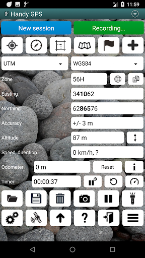
This app is a powerful navigation tool designed for outdoors sports like hiking, bushwalking, tramping, mountain biking, kayaking, boating, horse trail riding, geocaching. Its also useful for surveying, mining, archaeology, and forestry applications. Its simple to use and works even in the remotest back country since it doesn't require network connectivity. It allows you to work in UTM or lat/lon coordinates so you can even use it with your paper maps.
NOTE: Allow the app to always use GPS, and turn off battery optimisation for the app to reliably record tracklogs when the phone …
Read the full description
The perfect companion for your next outdoor adventure. Seek, find, record and return home with Handy GPS. This app is a powerful navigation tool designed for outdoors sports like hiking, bushwalking, tramping, mountain biking, kayaking, boating, horse trail riding, geocaching. Its also useful for surveying, mining, archaeology, and forestry applications. Its simple to use and works even in the remotest back country since it doesn't require network connectivity. It allows you to work in UTM or lat/lon coordinates so you can even use it with your paper maps. NOTE: Allow the app to always use GPS, and turn off battery optimisation for the app to reliably record tracklogs when the phone screen is off. BASE FEATURES: * Shows your current coordinates, altitude, speed, direction of travel, and distance travelled in metric, imperial/US, or nautical units. * Can store your current location as a waypoint, and record a track log to show where you've been on a map. * Data can be imported from and exported to KML and GPX files. * Allows manual entry of waypoints in UTM, MGRS and lat/lon coords. * Can guide you to a waypoint using the "Goto" screen, and optionally sound an alert when when you're getting close. * Has a compass page which works on devices with magnetic field sensors. * Automatically computes the local geoid offset to improve altitude accuracy * Supports the world-wide WGS84 datum along with the common Australian datums and map grids (AGD66, AGD84, AMG, GDA94, and MGA). You can also use WGS84 for NAD83 maps in the US. * Shows GPS satellite locations and signal strengths graphically. * Can display simple or MGRS grid references. * Can compute waypoint-to-waypoint distance and direction. * Includes an optional timer line to record walk duration and compute your average speed. * Thoroughly tested by the developer on many off-track walks EXTRA FEATURES IN THIS VERSION: * No ads, no subscriptions, and nothing more to pay after your initial purchase. * Unlimited number of waypoints and track log points. * Email or SMS your location to a friend as a clickable map link. * Email your waypoints and tracklogs as KML or GPX file. * Supports common datums such as NAD83 (US), OSGB36 (UK), NZTM2000 (NZ), SAD69 (South America) and ED50 (Europe), and you can configure your own custom datums, including local grid systems. * UK grid refs with two letter prefixes can be shown if OSGB datum selected. * Elevation profile. * GPS averaging mode. * Take photos and record voice memos, geo-located with KML files for easy viewing on a PC. * Geo-tag photos, and/or have the coordinates and bearing "burnt" into the image. * Sun rise and set times. * Export data to CSV file. * Create waypoint by triangulation, or projecting using an entered distance and bearing. * Compute length, area, and elevation change for tracklog. * Offline map support by downloading tiles from map tile servers, importing pre-prepared base maps from zip files, or registering your own map images. * Compute calories. * Optional background image. * Optional location sharing on web. * Spoken distance and direction guidance on goto page. PERMISSIONS: (1) GPS, to show your location, (2) Network access, to load maps, (3) SD card access, to load and store waypoints, (4) Camera access, for taking pics, (5) Prevent phone from sleeping, so proximity alarm works, (6) Control flashlight, to allow flashlight use, (7) Record audio for voice memos. DISCLAIMER: You use this app at your own risk. The developer accepts no responsibility for you getting lost or injured as a result of using this app. Batteries in mobile devices can go flat. For extended and remote hikes, a battery bank and an alternative method of navigation such as a paper map and compass are recommended for safety.
Installs since 27 Aug 2026 Measured
Exact Google Play install counts, collected daily
Ratings
614 ratings, 55 reviews
- 5 ★71%
- 4 ★16%
- 3 ★1.0%
- 2 ★1.0%
- 1 ★11%
Recent reviews
Latest public reviews from the store
- 22 Apr 2022
I like this app
- 19 Aug 2020
I found only this app of video Arabic songs after searching for a long time. Luckily, it's working smoothly. 👍
Top chart positions
Latest Google Play chart ranks by country, last 10 days
Not in any tracked top chart in the last 10 days.
Handy GPS history
Release, install milestones, listing and store changes
- First released on the store 22 Aug 2012
Update frequency
How often Handy GPS ships a new version, month by month
5 updates in the last 12 months. More often than most similar apps: they shipped a median of 1 updates in the same year.
Recent versions
Current version 45.7
- Version 45.621 Oct 2026
45.6: Prevent crashes and timeouts by only displaying at most 10,000 tracklog points on map. 45.5: Update the compass and Goto pages to use a more modern compass style. The old style is still available in general preferences. 45.4: When viewing photos taken within app, rotate to correct orientation. 45.3: Fixed bug with offline maps. 45.2: Added support for offline basemaps in XYZ tile format. 45.1: Upgraded Android libraries as required by Google.
- Version 45.225 Aug 2026
45.2: Added support for offline basemaps in XYZ tile format. 45.1: Upgraded Android libraries as required by Google. 45.0: Fixed crash bugs related to screen rotation. Prevent phone screen sleeping while downloading map tiles to prevent interruptions. 44.9: Start spoken distances 5 km (3 miles) from goto target. 44.8: Improved performance of unzip map files and show progress.
- Version 45.09 Jul 2026
45.0: Fixed crash bugs related to screen rotation. Prevent phone screen sleeping while downloading map tiles to prevent interruptions. 44.9: Start spoken distances 5 km (3 miles) from goto target. 44.8: Improved performance of unzip map files and show progress. 44.6: Improved performance of offline maps. Changed default map zoom to be 15 instead of 16. Added a button to import offline maps from zip files. 44.5: Updated Google library. 44.4: Updated magnetic field and geoid models.
- Version 44.919 Apr 2026
44.9: Start spoken distances 5 km (3 miles) from goto target. 44.8: Improved performance of unzip map files and show progress. 44.6: Improved performance of offline maps. Changed default map zoom to be 15 instead of 16. Added a button to import offline maps from zip files. 44.5: Updated Google library. 44.4: Updated magnetic field and geoid models.
Listing keywords
Words and phrases Handy GPS repeats most in its store listing
Top phrases: access to load (2), distance and direction (2), handy gps (2), lat lon (2), track log (2).
Highlighted words also appear in the title. Counts cover the title, short description and description.
Business model and tech
From the store listing and declared permissions
- Business model
- Paid, $11.99In-app purchases
- Sensitive access
- No sensitive permission declared
Compliance
What the listing and the app package show
- Store status
- Live
- Upkeep
- Updated 21 Oct 2026
- Registered in
- Australia
- Privacy policy
- Linked on the listing
- Advertising
- No ads declared
- In-app purchases
- Offered
- Age rating
- Everyone
Apps like Handy GPS
Total TrafficiHeartMedia, Inc.80.8K installs★ 2.97
CycleStreets journey plannerCycleStreets Ltd136K installs★ 3.0
Park EvanstonPassport Labs, Inc.102K installs★ 3.93
1899대리운전1899대리운전185K installs★ 4.1
CRE ToolboxCR England65.9K installs★ 3.05
Coordinate Converter PlusTennyson Chingombe200K installs★ 4.03
DashCam (Dashboard Camera)Hamerkop Ltd192K installs★ 2.75
BusWhere for SchoolsBusWhere51K installs★ 4.38
Pame AppCyprus Public Transport164K installs★ 2.42
Handy GPS: questions and answers
How many downloads does Handy GPS have?
Handy GPS has 26,516 installs on Google Play, measured from the store's own count on 19 Nov 2026.
Who makes Handy GPS?
Handy GPS is published by BinaryEarth, a developer based in AU.
When was Handy GPS last updated?
The latest version (45.7) was released on 21 Oct 2026.
Is Handy GPS free?
No. Handy GPS is a paid app priced at $11.99.
Is Handy GPS still available?
Yes. Handy GPS is live on Google Play as of 19 Nov 2026.
Track Handy GPS and its competitors
Watch any app for new versions, rating drops, chart moves and removals. Free plan, no card.