
IGNIS | Wildfire Operations
GPS Mapping for Wildland Fire
- Installs
- 5.98K
- Measured
- Rating
- 4.39
- Ratings
- 29
- 14 reviews
- Version
- Varies with device
- Updated 25 Feb 2026
- Released
- 27 May 2025
- Tracked since 13 May 2026
- Size
- —
Also on App Store: IGNIS | Wildfire Operations (47 ratings)
Screenshots

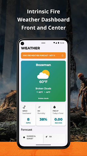


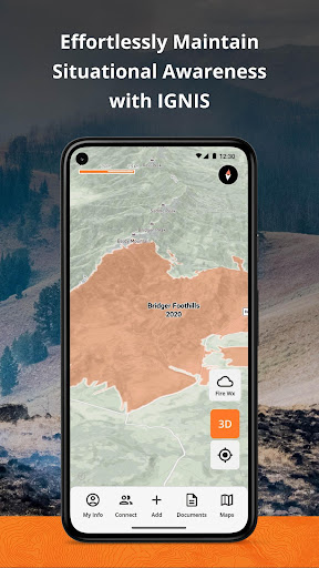


About IGNIS | Wildfire Operations
The description on the store listing
**Fireline Mapping Transformed with IGNIS**
IGNIS redefines situational awareness, by centralizing essential fireline intelligence, offering unmatched capabilities: overlay GeoPDF maps on dynamic base maps, access curated wildland fire layers, utilize the Fire Weather Dashboard for detailed forecasts, and tap into fire-specific symbology and reference documents. Say goodbye to endless tabs and apps—IGNIS streamlines workflows, saving time and effort in the field.
**Step into the future of firefighting safety today.**
**IGNIS Core: FREE for Firefighters—Because the Right Tools Make a Difference**
Access powerful fire intelligence tools right at your fingertips, so you can focus …
Read the full description
**Fireline Mapping Transformed with IGNIS** IGNIS redefines situational awareness, by centralizing essential fireline intelligence, offering unmatched capabilities: overlay GeoPDF maps on dynamic base maps, access curated wildland fire layers, utilize the Fire Weather Dashboard for detailed forecasts, and tap into fire-specific symbology and reference documents. Say goodbye to endless tabs and apps—IGNIS streamlines workflows, saving time and effort in the field. **Step into the future of firefighting safety today.** **IGNIS Core: FREE for Firefighters—Because the Right Tools Make a Difference** Access powerful fire intelligence tools right at your fingertips, so you can focus on what matters most: the task at hand. **Key Features:** - Store unlimited GeoPDF maps and layer them on dynamic base maps with 3D views. - Download sections of the base map for offline access. - Access fire-specific weather, including zone forecasts and location-based weather reports. - Build custom incident maps with fire-specific symbology. - Record tracks, draw lines, drop points, and calculate areas in acres. - Access essential reference documents directly in the app. - Curated map layers designed for wildland fire, including: - Severe Fire Danger Index - Fire Weather Advisories - Ground Medevac Transport Times - Current Incidents - Current & Historical Fire Perimeters - NOAA Weather Radar - ALERTCalifornia Cameras - Satellite Heat Detection - Wind Speed & Direction - And more! **IGNIS CONNECT: OFFLINE TEAM COLLABORATION** Take fireline coordination to the next level with IGNIS Connect. Everything in IGNIS Core, plus: - Team coordination through offline Bluetooth mesh networking. Share points, lines, and polygons—even without cell service. - A web app for centralized organization management, document and map sharing, and interactive mapping. - Unified coordination for field crews and office teams, keeping everyone aligned. Terms of Use: https://www.ignistech.io/terms-of-use [](https://www.ignistech.io/terms-of-use)Privacy Policy: https://www.ignistech.io/privacy-policy Get Help or Leave Feedback: https://help.ignistech.io/ Or email [email protected]
Installs since 29 Aug 2026 Measured
Exact Google Play install counts, collected daily
Ratings
29 ratings, 14 reviews
- 5 ★83%
- 4 ★0.0%
- 3 ★0.0%
- 2 ★0.0%
- 1 ★17%
Recent reviews
Latest public reviews from the store
- 4 Apr 2026
2048 cricket is very engaging
- 6 Feb 2026
nice 2048 game. Really enjoy it
- 4 Feb 2026
nice game
- 26 Jan 2026
Excellent Game
Top chart positions
Latest Google Play chart ranks by country, last 10 days
Not in any tracked top chart in the last 10 days.
IGNIS | Wildfire Operations history
Release, install milestones, listing and store changes
- Reached 500+ installs 25 Feb 2026
- Reached 100+ installs 2 Jul 2025
- Reached 50+ installs 4 Jun 2025
- First released on the store 27 May 2025
Listing keywords
Words and phrases IGNIS | Wildfire Operations repeats most in its store listing
Top phrases: fire specific (3), wildland fire (3), dynamic base maps (2), fire specific symbology (2), base maps (2).
Highlighted words also appear in the title. Counts cover the title, short description and description.
Business model and tech
From the store listing and declared permissions
- Business model
- Free to download
- Sensitive access
- No sensitive permission declared
Compliance
What the listing and the app package show
- Store status
- Live
- Upkeep
- Updated 25 Feb 2026
- Registered in
- United States
- Privacy policy
- Linked on the listing
- Advertising
- No ads declared
- In-app purchases
- None declared
- Age rating
- Everyone
Apps like IGNIS | Wildfire Operations
Такси "Рус-авто"BIT Master5.2K installs★ 4.0
TCS GoSafe MobileTata Consultancy Services Limited11.4K installs★ 1.0
부산버스 스마트OU Apps36.4K installs★ 3.7
Train Tracker BD LiveMD. Marajul Haque1.7K installs★ 4.78
AP Transit - NYC Subway MapAlexander Pozharov1.9K installs★ 4.33
Zirak CaptainZIRAK LLC2K installs★ 4.33
Diground ~Create and Share MAPDiground Inc.15.6K installs★ 3.1
ORIZOTecelys73.8K installs★ 3.6
VocaBus Horaires en temps réelSTGA9.7K installs★ 4.0
IGNIS | Wildfire Operations: questions and answers
How many downloads does IGNIS | Wildfire Operations have?
IGNIS | Wildfire Operations has 5,982 installs on Google Play, measured from the store's own count on 7 Nov 2026.
Who makes IGNIS | Wildfire Operations?
IGNIS | Wildfire Operations is published by Ignis Technologies, a developer based in US.
When was IGNIS | Wildfire Operations last updated?
The latest version (Varies with device) was released on 25 Feb 2026.
Is IGNIS | Wildfire Operations free?
Yes. IGNIS | Wildfire Operations is free to download.
Is IGNIS | Wildfire Operations still available?
Yes. IGNIS | Wildfire Operations is live on Google Play as of 7 Nov 2026.
Track IGNIS | Wildfire Operations and its competitors
Watch any app for new versions, rating drops, chart moves and removals. Free plan, no card.