
iNavX: Marine Navigation
Now on Android - Advanced Handheld Chartplotter & Marine Navigation Application
- Installs
- 425K
- Measured
- Rating
- 3.15
- Ratings
- 983
- 118 reviews
- Version
- 1.6.8
- Updated 21 Oct 2025
- Released
- 14 Dec 2017
- Tracked since 12 May 2026
- Size
- 55 MB
- Needs 4.4W
Also on App Store: iNavX: Marine Navigation (21.9K ratings)
Screenshots
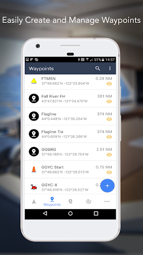
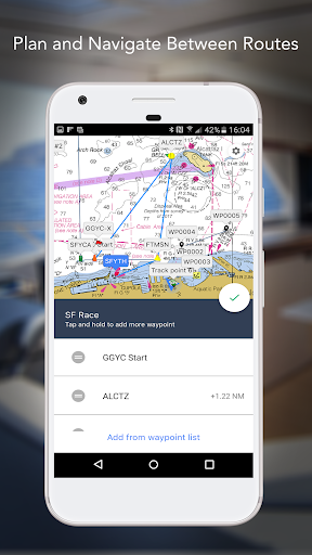


About iNavX: Marine Navigation
The description on the store listing
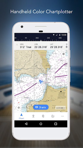
Marine navigation is made easy with iNavX - the world's #1 handheld Chartplotter. Access marine charts, maps, weather, AIS and more!
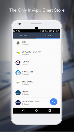
iNavX is the only app to give you complete worldwide chart coverage, from all your favorite charts providers, including the ALL NEW iNavX Professional+ Global Chart! Fully enabled with one-touch access, iNavX gives users access to the broadest set of marine charts and maps from multiple providers including:
• iNavX Professional+ Charts
• Blue Latitude
• Explorer
• Theyr Weather
• Waterway Guide
• … and more
How does iNavX take handheld marine navigation to the next level?
• Sailors - Plan sailing routes with waypoint and route management. …
Read the full description
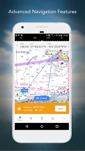
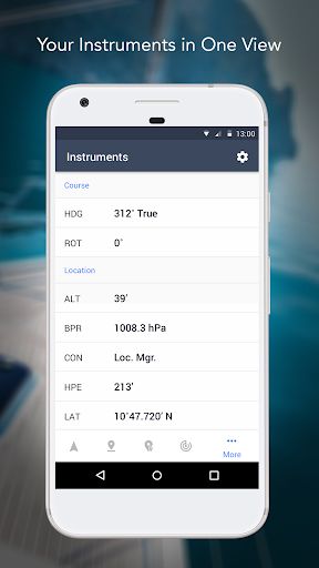
Marine navigation is made easy with iNavX - the world's #1 handheld Chartplotter. Access marine charts, maps, weather, AIS and more! iNavX is the only app to give you complete worldwide chart coverage, from all your favorite charts providers, including the ALL NEW iNavX Professional+ Global Chart! Fully enabled with one-touch access, iNavX gives users access to the broadest set of marine charts and maps from multiple providers including: • iNavX Professional+ Charts • Blue Latitude • Explorer • Theyr Weather • Waterway Guide • … and more How does iNavX take handheld marine navigation to the next level? • Sailors - Plan sailing routes with waypoint and route management. Get proactive sail management with GRIB weather forecasts and then keep watch with AIS overlays and integration with your onboard systems. Plus, you can remember your great sailing locations by geotagging photos. • Boaters - Stay up to date on boating conditions with forecasts that include currents, winds, and swells. Manage your boating equipment with nautical instrument integration and then save great boating routes to share with the track log. • Anglers - Discover new fishing spots by scouting out holes and inlets. Locate the best fishing conditions by identifying cold fronts and save your best fishing spots with unlimited markers. Advanced features - iNavX is the most feature rich app available for all sailing and boating needs at a great price: Advanced Chart Plotter • Plot your position in real-time using your device's built-in GPS • Pan, zoom, and rotate charts (including course up) • Print detailed charts to use in combination with the app Advanced Navigation • Create waypoints and plan routes to navigate between them • Track log allows you to record your route • Import/export data in KML (Google Earth) or GPX format Advanced Instrumentation • Supports NMEA data over TCP/IP (using Wifi) • Integrates with external GPS, AIS receivers & transponders • Connect nautical instruments: Depth, Speed, Wind, Engine, Batteries, etc. Essential Toolkit • GRIB weather forecast • Tides/currents • Anchor alarm • AIS integration • Port/navaid search Download iNavX TODAY and automatically receive a complimentary copy of the official and up-to-date high-resolution NOAA RNC United States marine raster charts. REVIEWS “iNavX is the original and still one of the best navigation apps.” – Practical Sailor “The most full-featured navigation app around and viewed by many as the standard” – Sail Magazine "The #1 recommended marine charting app" - iMarineApps iNavX is Compatible with: C-MAP, Theyr Weather, Waterway Guide, AIS, Brookhouse, DigitalYacht, ShipModul, vYacht, Vesper Marine, NMEA 2000, Chetco and more. NEW CHART STORE Purchase all your favorite charts. Chart subscriptions vary by chart and provider from $9.99 to $199.99 annually, charged to your iTunes Account, which will automatically renew unless cancelled at least 24 hours before the end of the current period. Auto-renew can be turned off anytime by going to your Account Settings in iTunes after purchase. No cancellation of the current subscription is allowed during active subscription period. NOTE: Continued use of GPS running in the background can dramatically decrease battery life. MORE INFO Website: http://inavx.com/ User's Guide: http://inavx.com/help/ Terms of Use: http://inavx.com/terms Privacy Policy: http://inavx.com/privacy
Installs since 29 Aug 2026 Measured
Exact Google Play install counts, collected daily
Ratings
983 ratings, 118 reviews
- 5 ★44%
- 4 ★4.6%
- 3 ★3.7%
- 2 ★11%
- 1 ★37%
Recent reviews
Latest public reviews from the store
- 6 Apr 2026
It works good
- 15 Mar 2026
this is amazing you can create a empire fo r Italy
- 9 Mar 2026
use it often, thank you
- 21 Feb 2026
100 %
What reviewers bring up
Topics mentioned in the latest 50 reviews, by how many reviews mention them
Liked in good reviews (37 reviews)
- tried 2
Raised in bad reviews (10 reviews)
No topic comes up twice.
Top chart positions
Latest Google Play chart ranks by country, last 10 days
Not in any tracked top chart in the last 10 days.
iNavX: Marine Navigation history
Release, install milestones, listing and store changes
- Reached 100,000+ installs 10 Dec 2020
- Reached 50,000+ installs 15 May 2019
- Reached 10,000+ installs 13 Apr 2018
- Reached 5,000+ installs 30 Jan 2018
- First released on the store 14 Dec 2017
Update frequency
How often iNavX: Marine Navigation ships a new version, month by month
0 updates in the last 12 months. Less often than most similar apps: they shipped a median of 1 updates in the same year.
Recent versions
Current version 1.6.8
- Version 1.6.820 Oct 2025
App Stability
- Version 1.6.720 Jul 2025
- Version 1.6.625 Jul 2024
- Version 1.6.48 Oct 2023
Listing keywords
Words and phrases iNavX: Marine Navigation repeats most in its store listing
Top phrases: marine navigation (4), theyr weather waterway (2), weather waterway guide (2), favorite charts (2), fishing spots (2).
Highlighted words also appear in the title. Counts cover the title, short description and description.
Business model and tech
From the store listing, the SDKs in the app package and its declared permissions
- Business model
- Free to downloadIn-app purchasesShows ads
- Built with
- No cross-platform framework or game engine detected
- Ad networks (1)
- AdMob
- Subscriptions and payments
- Google Play billing
- Attribution and measurement
- AppsFlyerBranch
- Analytics and crash reports
- AmplitudeFirebaseGoogle AnalyticsCrashlyticsfabric
- Sign-in and social
- Sensitive access
- LocationCameraPhotos, videos and filesAdvertising ID
6 ad, attribution and analytics SDKs detected. SDKs are read from the app package and permissions from the store listing, so code that loads later is not seen.
Technology
25 SDKs found in the app package
Ad networks
Advertising and install-attribution SDKs found in the app package
- AdMob
- AppsFlyer
22 permissions
0 special access, 11 sensitive, 11 standard
- Take photos and videosSensitive
- Change or delete shared storageSensitive
- Read music and audioREAD_MEDIA_AUDIOSensitive
- Read photosREAD_MEDIA_IMAGESSensitive
- Read shared storageSensitive
- Read videosREAD_MEDIA_VIDEOSensitive
- Approximate locationSensitive
- Location in the backgroundACCESS_BACKGROUND_LOCATIONSensitive
- Precise locationSensitive
- Show notificationsPOST_NOTIFICATIONSSensitive
- Access USB storage filesystemSensitive
- Read how it was installed (install referrer)BIND_GET_INSTALL_REFERRER_SERVICEStandard
Compliance
What the listing and the app package show
- Store status
- Live
- Upkeep
- Updated 21 Oct 2025
- Registered in
- United States
- Privacy policy
- Linked on the listing
- Advertising
- No ads declared
- In-app purchases
- Offered
- Age rating
- Everyone
- Sensitive permissions
- 11 sensitive of 22
- Location access
- Yes, also in the background
- Camera and microphone
- Camera
Apps like iNavX: Marine Navigation
T-Track ProTracking System132K installs★ 3.4
FreightPro.ai (aka TruckBook)Truckbook Inc89.1K installs★ 3.43
TransitDB VancouverCarson Lam173K installs★ 4.5
Угона.нетkurchanov47.1K installs★ 2.4
Prevoz.orgLEGIT d.o.o.135K installs★ 3.67
FastToll IllinoisPragmistic LLC70.8K installs★ 3.42
MovaticMovatic129K installs★ 3.46
Rutas VeracruzMAHM187K installs★ 4.2
InTouchPassTime GPS29.1K installs★ 4.31
iNavX: Marine Navigation: questions and answers
How many downloads does iNavX: Marine Navigation have?
iNavX: Marine Navigation has 425,435 installs on Google Play, measured from the store's own count on 14 Nov 2026.
Who makes iNavX: Marine Navigation?
iNavX: Marine Navigation is published by NavX Studios, a developer based in US.
When was iNavX: Marine Navigation last updated?
The latest version (1.6.8) was released on 21 Oct 2025.
Is iNavX: Marine Navigation free?
Yes. iNavX: Marine Navigation is free to download and offers in-app purchases.
Is iNavX: Marine Navigation still available?
Yes. iNavX: Marine Navigation is live on Google Play as of 14 Nov 2026.
Track iNavX: Marine Navigation and its competitors
Watch any app for new versions, rating drops, chart moves and removals. Free plan, no card.