
MilGPS
MGRS, UTM map, compass, track recording, offline maps.
- Installs
- 345
- Measured
- Rating
- —
- Ratings
- —
- Version
- Varies with device
- Released
- 16 Apr 2026
- Tracked since 31 May 2026
- Size
- —
Screenshots


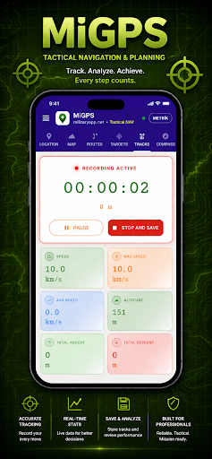


About MilGPS
The description on the store listing
MilGPS is a comprehensive GPS navigation and coordinate management app
designed for field use. A reliable field tool for military operations,
search and rescue, hunting, mountaineering, and outdoor activities.
━━━ COORDINATE SYSTEMS ━━━
- MGRS, UTM, USNG, QTH and LAT/LON support
- Instant conversion between coordinate formats
- Copy and share current location with a single tap
━━━ MAP ━━━
- Topographic, road, satellite and hybrid map layers
- Shadow relief, contour line and street name overlay layers
- Military coordinate grid displayed visually on the map
- Add waypoints with long press, drag to reposition
- Coordinate search: decimal, MGRS and DMS formats supported
- 3D …
Read the full description
MilGPS is a comprehensive GPS navigation and coordinate management app designed for field use. A reliable field tool for military operations, search and rescue, hunting, mountaineering, and outdoor activities. ━━━ COORDINATE SYSTEMS ━━━ - MGRS, UTM, USNG, QTH and LAT/LON support - Instant conversion between coordinate formats - Copy and share current location with a single tap ━━━ MAP ━━━ - Topographic, road, satellite and hybrid map layers - Shadow relief, contour line and street name overlay layers - Military coordinate grid displayed visually on the map - Add waypoints with long press, drag to reposition - Coordinate search: decimal, MGRS and DMS formats supported - 3D terrain view — real elevation model over satellite imagery ━━━ OFFLINE MAP ━━━ - Cache the visible map area by zoom level - Full functionality without internet connection - Regional, district and neighborhood scale cache presets ━━━ WAYPOINTS ━━━ - Save and manage named waypoints - Bulk import from GPX, KML, CSV and MGRS list formats - Export all waypoints as a GPX file - Distance and bearing between waypoints - Start navigation to a selected waypoint ━━━ ROUTE ━━━ - Create multi-point routes by tapping on the map - Load routes from GPX and KML files - Save and export routes as GPX - Route distance displayed in real time - Mission mode: deviation tracking and heading guidance along route ━━━ TRACK RECORDING ━━━ - Real-time track recording: duration, distance, max and average speed - Total ascent and descent elevation - View recorded tracks on the map - Export tracks in GPX format ━━━ COMPASS ━━━ - Real-time heading, target bearing and relative bearing display - Target alignment bar: on route / slight deviation / off route alerts - Estimated time of arrival (ETA) - Speed, altitude and accuracy readout ━━━ TOOLS ━━━ - LAT/LON → MGRS and UTM coordinate converter - Area calculator: polygon point selection in m² and km² - Distance measurer: total distance along route - Metric / imperial unit toggle - Local time and Zulu (UTC) time display ━━━ GPS & SENSORS ━━━ - Live location, altitude, speed, heading and accuracy - Terrain classification: flat / hill / mountain / high mountain - Barometer support: atmospheric pressure and barometric altitude - Animated GPS status indicator ━━━ INTERFACE ━━━ - Dark and light theme - 6 tabs: Location, Map, Waypoints, Tracks, Compass, Tools ━━━ LANGUAGE SUPPORT ━━━ - 21 languages: Turkish, English, German, French, Spanish, Italian, Portuguese, Russian, Arabic, Chinese, Japanese, Korean, Dutch, Polish, Swedish, Norwegian, Danish, Finnish, Czech, Hungarian, Romanian
Installs Measured
Exact Google Play install counts, collected daily
Daily history starts once this app is in our daily install sample.
Ratings
- 5 ★0.0%
- 4 ★0.0%
- 3 ★0.0%
- 2 ★0.0%
- 1 ★0.0%
Recent reviews
Latest public reviews from the store
No reviews in our sample for this app yet.
Top chart positions
Latest Google Play chart ranks by country, last 10 days
Not in any tracked top chart in the last 10 days.
MilGPS history
Release, install milestones, listing and store changes
- First released on the store 16 Apr 2026
Update frequency
How often MilGPS ships a new version, month by month
0 updates in the last 12 months. Less often than most similar apps: they shipped a median of 1 updates in the same year.
Listing keywords
Words and phrases MilGPS repeats most in its store listing
Top phrases: track recording (3), along route (2), lat lon (2), mgrs utm (2).
Highlighted words also appear in the title. Counts cover the title, short description and description.
Business model and tech
From the store listing and declared permissions
- Business model
- Paid, $10.99
- Sensitive access
- No sensitive permission declared
Compliance
What the listing and the app package show
- Store status
- Live
- Privacy policy
- Linked on the listing
- Advertising
- No ads declared
- In-app purchases
- None declared
- Age rating
- Everyone
Apps like MilGPS
كيمو | Kimo : Taxi App LibyaTaxisti Company5.2K installs★ 2.8
Такси "Рус-авто"BIT Master5.2K installs★ 4.0
TCS GoSafe MobileTata Consultancy Services Limited11.4K installs★ 1.0
부산버스 스마트OU Apps36.4K installs★ 3.7
Train Tracker BD LiveMD. Marajul Haque1.7K installs★ 4.78
AP Transit - NYC Subway MapAlexander Pozharov1.9K installs★ 4.33
Zirak CaptainZIRAK LLC2K installs★ 4.33
Diground ~Create and Share MAPDiground Inc.15.6K installs★ 3.1
ORIZOTecelys73.8K installs★ 3.6
MilGPS: questions and answers
How many downloads does MilGPS have?
MilGPS has 345 installs on Google Play, measured from the store's own count on 31 May 2026.
Who makes MilGPS?
MilGPS is published by Military App.
Is MilGPS free?
No. MilGPS is a paid app priced at $10.99.
Is MilGPS still available?
Yes. MilGPS is live on Google Play as of 31 May 2026.
Track MilGPS and its competitors
Watch any app for new versions, rating drops, chart moves and removals. Free plan, no card.