
- Installs
- —
- Apple does not publish download counts
- Rating
- 5.0
- Ratings
- 6
- 6 reviews
- Version
- 1.9.2
- Updated 19 Jan 2024
- Released
- 1 Apr 2010
- Tracked since 10 May 2026
- Size
- 66 MB
- Needs 16.1
Screenshots


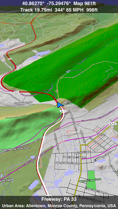


About Scenic Map Eastern USA
The description on the store listing
A 3D topo map of the Eastern USA. The vector map data is contained within the app and can be used without an internet connection. Use it in a car, a boat, a plane or while hiking. It is like having more than a third of the country in your pocket.
Scenic Map now covers the entire world via online maps. The maps are cached automatically so they can still be used when there is no cell coverage. Turn on Online Map in the Settings menu and you can then scroll or go to any location on the planet. Satellite image overlays add breathtaking detail and realism to the maps (tap preset 2 or 4 when Online Map is enabled). You can use them as you travel to see what is hidden from view at ground level. …
Read the full description
A 3D topo map of the Eastern USA. The vector map data is contained within the app and can be used without an internet connection. Use it in a car, a boat, a plane or while hiking. It is like having more than a third of the country in your pocket. Scenic Map now covers the entire world via online maps. The maps are cached automatically so they can still be used when there is no cell coverage. Turn on Online Map in the Settings menu and you can then scroll or go to any location on the planet. Satellite image overlays add breathtaking detail and realism to the maps (tap preset 2 or 4 when Online Map is enabled). You can use them as you travel to see what is hidden from view at ground level. This takes moving maps to a whole new level. Use the two finger vertical swipe gesture to tilt the map for a 3D view. Scroll like a map or fly like a flight simulator. Enable Joystick Gestures in the Settings menu and then fly around the terrain using a virtual joystick. Prefer only 2D maps? Enable the 2D Map option in the Settings menu. Scenic Map is simply the best 3D topo map available for a mobile device. You will see incredible detail while scrolling, rotating and zooming perfectly smoothly. You will see every road even if you zoom out to the altitude of a satellite. As you zoom in, you will see every small bump and hollow of the Earth and terrain features as small as ten meters. Unlike old fashioned topo maps, Scenic Map’s roads and trails are up to date thanks to OpenStreetMap.org. It contains polygons for urban areas, shopping malls, an ever growing number of buildings and many other features, The best lake, pond, stream and rivers from the USGS and Canadian public databases are also included. Tap the GPS center button to begin tracking your location. As you move, you will generate a track file. Tracks can be replayed with video like controls to speed up, slow down, pause, restart or skip to the end. You can display existing tracks while recording another if you want to retrace your route. When online, you can automatically create a route from your current GPS location to any other point on the map. Tracks can be received from or sent to other apps in GPX format. GPS recording stops automatically after you have remained stationary for some time or you can choose to manually stop tracking by tapping on the top track in the Tracks view. Never before have maps been this customizable. For example, you can turn on or off the roads. You can change the lighting direction or remove terrain shading entirely. You can display contour lines even over satellite images. There are five presets which let you quickly switch between map styles. Use Metric, English or Nautical units and choose one of four different coordinate displays including UTM. Want to learn more about a map feature? Tap the target icon and center the feature under the compass rose to display its name, type, urban area, county, state, elevation and coordinates. You will also see a bearing line back to your current GPS location or from your location to a selected waypoint. The status bar shows the bearing direction and distance along with the map and GPS elevation, the track length, and your current speed and direction of travel. In-app documentation is provided in the Help section at the top of the Settings menu. Links are provided in the documentation to detailed coverage maps, tutorial videos, installation guide and blog at ScenicMap.com Map data © OpenStreetMap and contributors under the Open Database License Scenic Map supports GPS tracking while the app is in the background. Caution: Continued use of GPS running in the background can dramatically decrease battery life.
Installs
Apple does not publish download counts. Estimates are in testing.
We publish iOS estimates only after they pass a back-test against real numbers. Chart history below is measured.
Estimated store revenue Estimated Beta
App Store, worldwide, monthly rate from the last 12 chart days to 19 Nov 2026
Below the top 100 grossing apps in the markets we calibrate. In the United States that usually means under about $6.4M a month. App Store purchases and subscriptions only, before Apple's 15 to 30% fee. Ads and web payments are not included.
Ratings
6 ratings, 6 reviews
No rating breakdown published for this app.
Recent reviews
Latest public reviews from the store
No reviews in our sample for this app yet.
Top chart positions
Latest App Store chart ranks by country, last 10 days
Not in any tracked top chart in the last 10 days.
Scenic Map Eastern USA history
Release, install milestones, listing and store changes
- First released on the store 1 Apr 2010
Update frequency
How often Scenic Map Eastern USA ships a new version, month by month
0 updates in the last 12 months. Less often than most similar apps: they shipped a median of 1 updates in the same year.
Recent versions
Current version 1.9.2
- Version 1.9.219 Jan 2024
Fast initial download. Maps are then dowloaded automatically. Fixed track recording in iOS 17. Fixed the settings menu in landscape mode on iPhone. Fixed low frame rate when the information bar is enabled. The map's highest detail is now displayed while scrolling.
Listing keywords
Words and phrases Scenic Map Eastern USA repeats most in its store listing
Top phrases: scenic map (4), settings menu (4), 3d topo map (2), current gps location (2), 3d topo (2).
Highlighted words also appear in the title. Counts cover the title, short description and description.
Compliance
What the listing and the app package show
- Store status
- Live
- Upkeep
- No update since 19 Jan 2024
- Age rating
- 4+
Apps like Scenic Map Eastern USA
 Canals.UKMARK MANSER★ 4.74
 Chevron Car WashDigital Mosaic Corporation★ 1.62
 hitta.sehittapunktse AB★ 4.6
 NextStop - NYC SubwayPliable Matter LLC★ 3.74
 E-Charge HKHong Kong EV Power Limited★ 4.34
 Simply NorthBusyBytes GmbH★ 4.08
 Doyle GuidesChris Doyle Publishing Limited★ 4.32
 Speedometer Speed MPH TrackerRihab Mehboob★ 4.62
 Property Line Finder - ParcelHealth & Wellness Apps Limited★ 4.28
Scenic Map Eastern USA: questions and answers
Who makes Scenic Map Eastern USA?
Scenic Map Eastern USA is published by GrangerFX.
When was Scenic Map Eastern USA last updated?
The latest version (1.9.2) was released on 19 Jan 2024.
Is Scenic Map Eastern USA free?
No. Scenic Map Eastern USA is a paid app priced at $4.99.
Is Scenic Map Eastern USA still available?
Yes. Scenic Map Eastern USA is live on App Store as of 1 Jul 2026.
Track Scenic Map Eastern USA and its competitors
Watch any app for new versions, rating drops, chart moves and removals. Free plan, no card.