
- Installs
- —
- Apple does not publish download counts
- Rating
- 4.77
- Ratings
- 549
- 549 reviews
- Version
- 4.3.3
- Updated 11 Oct 2026
- Released
- 10 Feb 2012
- Tracked since 10 May 2026
- Size
- 52 MB
- Needs 12.2
Also on Google Play: SkyDemon (2.8K ratings)
Screenshots
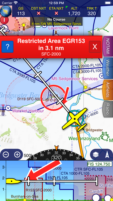
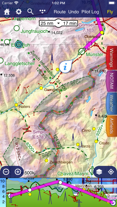
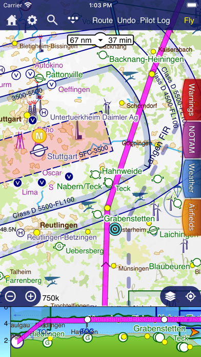
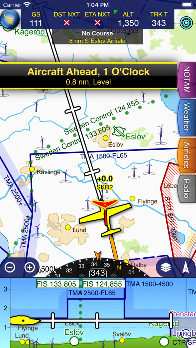
About SkyDemon
The description on the store listing
SkyDemon is Europe's favourite software for VFR flight planning and in-flight navigation.
Use this app to access your SkyDemon subscription on your iOS device, unlocking SkyDemon's powerful features while on the move.
FLIGHT PLANNING FEATURES
- SkyDemon vector charts are the clearest aeronautical charts you'll ever use, with dynamic airspace clipping and choice of map layers
- Route planning is as simple as touching consecutive waypoints and dragging to make changes
- Virtual Radar shows how your route relates to airspace, terrain, obstructions and other features
- Pilot Log facility calculates headings and groundspeeds from actual wind data, and shows useful frequencies
- Plates and …
Read the full description
SkyDemon is Europe's favourite software for VFR flight planning and in-flight navigation. Use this app to access your SkyDemon subscription on your iOS device, unlocking SkyDemon's powerful features while on the move. FLIGHT PLANNING FEATURES - SkyDemon vector charts are the clearest aeronautical charts you'll ever use, with dynamic airspace clipping and choice of map layers - Route planning is as simple as touching consecutive waypoints and dragging to make changes - Virtual Radar shows how your route relates to airspace, terrain, obstructions and other features - Pilot Log facility calculates headings and groundspeeds from actual wind data, and shows useful frequencies - Plates and other documents for relevant airfields are displayed automatically as you plan, and many are available georeferenced for use in flight - Intuitive pan, pinch and rotate support with no loss of map clarity or text legibility - File a VFR flightplan for your route directly to air traffic controllers - Automatic TAF, METAR and SIGMET briefing as you plan a route, with graphical decoding - Rainfall data can be overlaid on the main map, with animation, showing the trend of rainfall over time - Integration of GAFOR route forecasts for Switzerland, Austria, Slovenia and Croatia - Both narrow-route and area NOTAM briefings available, updated as you plan - Advanced NOTAM graphical interpretation and depiction on the main map - Easily print your PLOG and the output from various briefings - Warnings for airspace and other potential hazards to your flight, updated in real time - Airfield Admin Information shows useful contacts and other details for airfields featured in our charts - Forecast winds aloft are automatically retrieved for the flight time and displayed on the map - Create an advanced flight performance profile for each aircraft you use - ATS Routes mode offers an alternative chart presentation for flight along airways - Accurate fuel, weight and balance calculations including flight costings - Create an unlimited number of user-defined waypoints - Analyse your track logs for posterity - Choose between six different vector chart styles - Extensive European chart coverage as standard GPS NAVIGATION FEATURES - Intelligent warnings for approaching airspace, NOTAM, obstacles, terrain and other hazards - Virtual Radar shows a side-on projection of all approaching features and how your trajectory relates to them - Vector map automatically follows the aircraft in north up, track up or course up orientation - Clear and concise instruments show you flight statistics and help keep you on track - An HSI/ILS instrument helps you keep to your planned route and line up early for approach - Live Pilot Log shows progress through your route, ETAs, ATAs and useful frequencies based on your current position - TerrainSafe dynamically colours mountainous terrain around you to quickly identify safer areas - Direct To allows easy re-routing in a hurry by picking from a selection of nearby airfields - Approach Information shows runway diagrams, TAF, METAR, NOTAM and other airfield details useful for making an approach - Live updates of TAF and METAR while in flight, with associated alerts* - Extended runway centrelines appear automatically on the map as you near your destination airfield - Permanent display of position relative to nearest well-known waypoint, for position reporting - Easy changing of the planned route while in flight by touching and dragging Continued use of GPS running in the background can dramatically decrease battery life. * Internet connection required for live weather update while in flight
Installs since 29 Aug 2026
Apple does not publish download counts. Estimates are in testing.
Estimated store revenue Estimated Beta
App Store, worldwide, monthly rate from the last 12 chart days to 19 Nov 2026
Below the top 100 grossing apps in the markets we calibrate. In the United States that usually means under about $6.4M a month. App Store purchases and subscriptions only, before Apple's 15 to 30% fee. Ads and web payments are not included.
Ratings
549 ratings, 549 reviews
No rating breakdown published for this app.
Recent reviews
Latest public reviews from the store
- 1 Mar 2024
Ppl
It’s one of the best app to used during my flying in london
- 4 Oct 2020
Excellent
This is the best soft ware we ever came across Easy to use and priced very reasonable
- 14 Dec 2019
The best in the UK.
Tried runway HD, didn’t think it was as easy. Skydemon is intuitive, easy, and mega helpful. Such a good app. Worth every penny.
- 1 May 2019
A few additions would be greatly appreciated
The product should develop more capabilities for IFR flying 1) synthetic vision 2) possibility to file IFR flight plans to eurocontrol 3) recommend recently filed flight plans for the route that the user wishes to fly. These last 2 feature would eliminate the need to subscribe to Rocket Route and could definitely represent great value 4) possibility to subscribe to and integrate Jeppesen IFR charts 5) integration with ADL210 device for weather, METARs and TAFs coverage across Europe. All there capabilities are already present on ForeFlight which is now available in Europe and I am tempted to migrate to ForeFlight.
What reviewers bring up
Topics mentioned in the latest 8 reviews, by how many reviews mention them
Liked in good reviews (6 reviews)
- skydemon 2
- without 2
- worth 2
Raised in bad reviews (1 reviews)
No topic comes up twice.
Top chart positions
Latest App Store chart ranks by country, last 10 days
- Countries ranked
- 6 of 50
- Best rank
- #4
- Top 10 placements
- 2
- of 7 chart placements
- Average rank
- #49.6
Best countries on App Store
- 🇿🇦 South Africa · Top grossing, Navigation#4
- 🇷🇴 Romania · Top grossing, Navigation#7
- 🇬🇧 United Kingdom · Top grossing, Navigation#52
- 🇩🇪 Germany · Top grossing, Navigation#55
- 🇫🇷 France · Top grossing, Navigation#65
- 🇨🇿 Czechia · Top grossing, Navigation#68
| Country | Chart | Category | Rank | Best (10 days) | Date |
|---|---|---|---|---|---|
| 🇿🇦 South Africa | Top grossing | Navigation | #4 | #2 | 19 Nov 2026 |
| 🇷🇴 Romania | Top grossing | Navigation | #7 | #4 | 19 Nov 2026 |
| 🇬🇧 United Kingdom | Top grossing | Navigation | #52 | #27 | 17 Nov 2026 |
| 🇩🇪 Germany | Top grossing | Navigation | #55 | #24 | 11 Nov 2026 |
| 🇫🇷 France | Top grossing | Navigation | #65 | #20 | 15 Nov 2026 |
| 🇨🇿 Czechia | Top grossing | Navigation | #68 | #68 | 10 Nov 2026 |
| 🇿🇦 South Africa | Top free | Navigation | #96 | #96 | 10 Nov 2026 |
SkyDemon history
Release, install milestones, listing and store changes
- First released on the store 10 Feb 2012
Update frequency
How often SkyDemon ships a new version, month by month
5 updates in the last 12 months. More often than most similar apps: they shipped a median of 1 updates in the same year.
Recent versions
Current version 4.3.3
- Version 4.3.311 Oct 2026
- Waypoints and airspace applicable only to gliders is now shown only when you have selected a glider
- Version 4.3.212 Jul 2026
- The Rainfall weather overlay has increased spatial resolution and better colours - Flyable Conditions is now updated every 10 minutes (used to be 15) - Rainfall is now incorporated into Flyable Conditions
- Version 4.3.117 Jun 2026
- The What's Here experience has been redesigned to present information better - The Weather tab has been updated so it more clearly shows when conditions are marginal or bad - Aerial Photography now includes all airspace and other aeronautical data - Approach Information screen runway information redesigned
- Version 4.37 Jun 2026
- The What's Here experience has been redesigned to present information better - The Weather tab has been updated so it more clearly shows when conditions are marginal or bad - Aerial Photography now includes all airspace and other aeronautical data - Approach Information screen runway information redesigned
Listing keywords
Words and phrases SkyDemon repeats most in its store listing
Top phrases: virtual radar shows (2), approach live (2), flight planning (2), information shows (2), main map (2).
Highlighted words also appear in the title. Counts cover the title, short description and description.
Compliance
What the listing and the app package show
- Store status
- Live
- Upkeep
- Updated 11 Oct 2026
- Age rating
- 4+
Apps like SkyDemon
 奥维地图Beidou Hanglu Technology Co.,Ltd.★ 4.52
 دربونة - تطبيق الملاحة العراقيHAQIBAT ELMOMEN★ 4.43
 AirmateMyriel Aviation SA★ 4.55
 Ticket WiperTicket Wiper Corp★ 4.67
 COTA PlusVia Transportation, Inc.★ 4.74
 GPS Diagnostic: Satellite TestDavid Ryall★ 4.65
 Virginia Traffic CamerasLW Brands, LLC★ 4.69
 onTime LIRRMobileware Inc.★ 3.63
 Terra Map - Trail ExplorerGEC s.r.l.★ 4.59
SkyDemon: questions and answers
Who makes SkyDemon?
SkyDemon is published by Divelements Limited.
When was SkyDemon last updated?
The latest version (4.3.3) was released on 11 Oct 2026.
Is SkyDemon free?
Yes. SkyDemon is free to download.
Is SkyDemon still available?
Yes. SkyDemon is live on App Store as of 14 Nov 2026.
Track SkyDemon and its competitors
Watch any app for new versions, rating drops, chart moves and removals. Free plan, no card.