
SkyDemon
SkyDemon is Europe's leading VFR flight-planning and GPS navigation software.
- Installs
- 282K
- Measured
- Rating
- 4.14
- Ratings
- 2.8K
- 28 reviews
- Version
- 4.3.3
- Updated 13 Oct 2026
- Released
- 27 Mar 2013
- Tracked since 10 May 2026
- Size
- 26 MB
- Needs 4.1
Also on App Store: SkyDemon (549 ratings)
Screenshots
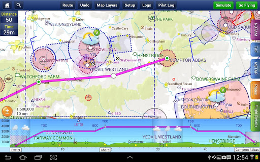


About SkyDemon
The description on the store listing
SkyDemon is one of Europe's most popular solutions for VFR flight planning and in-flight navigation.
Use this app to access your SkyDemon subscription on your Android device, unlocking SkyDemon's powerful features while on the move.
FLIGHT PLANNING FEATURES
- SkyDemon vector charts are the clearest aeronautical charts you'll ever use, with dynamic airspace clipping and choice of map layers
- Route planning is as simple as touching consecutive waypoints and dragging to make changes
- Virtual Radar shows how your route relates to airspace, terrain, obstructions and other features
- Pilot Log facility calculates headings and groundspeeds from actual wind data, and shows useful …
Read the full description
SkyDemon is one of Europe's most popular solutions for VFR flight planning and in-flight navigation. Use this app to access your SkyDemon subscription on your Android device, unlocking SkyDemon's powerful features while on the move. FLIGHT PLANNING FEATURES - SkyDemon vector charts are the clearest aeronautical charts you'll ever use, with dynamic airspace clipping and choice of map layers - Route planning is as simple as touching consecutive waypoints and dragging to make changes - Virtual Radar shows how your route relates to airspace, terrain, obstructions and other features - Pilot Log facility calculates headings and groundspeeds from actual wind data, and shows useful frequencies - Plates and other documents for relevant airfields are displayed automatically as you plan, and many are available georeferenced for use in flight - Intuitive pan, pinch and rotate support with no loss of map clarity or text legibility - File a VFR flightplan for your route directly to air traffic controllers - Automatic TAF, METAR and SIGMET briefing as you plan a route, with graphical decoding - Rainfall data can be overlaid on the main map, with animation, showing the trend of rainfall over time - Integration of GAFOR route forecasts for Switzerland, Austria, Slovenia and Croatia - Both narrow-route and area NOTAM briefings available, updated as you plan - Advanced NOTAM graphical interpretation and depiction on the main map - Easily print your PLOG and the output from various briefings - Warnings for airspace and other potential hazards to your flight, updated in real time - Airfield Admin Information shows useful contacts and other details for airfields featured in our charts - Forecast winds aloft are automatically retrieved for the flight time and displayed on the map - Create an advanced flight performance profile for each aircraft you use - ATS Routes mode offers an alternative chart presentation for flight along airways - Accurate fuel, weight and balance calculations including flight costings - Create an unlimited number of user-defined waypoints - Analyse your track logs for posterity - Choose between six different vector chart styles - Extensive European chart coverage as standard GPS NAVIGATION FEATURES - Intelligent warnings for approaching airspace, NOTAM, obstacles, terrain and other hazards - Virtual Radar shows a side-on projection of all approaching features and how your trajectory relates to them - Vector map automatically follows the aircraft in north up, track up or course up orientation - Clear and concise instruments show you flight statistics and help keep you on track - An HSI/ILS instrument helps you keep to your planned route and line up early for approach - Live Pilot Log shows progress through your route, ETAs, ATAs and useful frequencies based on your current position - TerrainSafe dynamically colours mountainous terrain around you to quickly identify safer areas - Direct To allows easy re-routing in a hurry by picking from a selection of nearby airfields - Approach Information shows runway diagrams, TAF, METAR, NOTAM and other airfield details useful for making an approach - Live updates of TAF and METAR while in flight, with associated alerts* - Extended runway centrelines appear automatically on the map as you near your destination airfield - Permanent display of position relative to nearest well-known waypoint, for position reporting - Easy changing of the planned route while in flight by touching and dragging * Internet connection required for live weather update while in flight
Installs, last 30 days Measured
Exact Google Play install counts, collected daily
Ratings
2,777 ratings, 28 reviews
- 5 ★71%
- 4 ★7.9%
- 3 ★0.0%
- 2 ★3.2%
- 1 ★17%
Recent reviews
Latest public reviews from the store
- 18 Mar 2026
Overall - a great areal navigation app, but boy it feels like it's made on some shaky foundations, for example when I'm browsing map on an android, anytime I zoom out - the map sometimes just flies towards a random direction for no traceable reason, and it's not a slight move, sometimes it flies half accross the globe... Other maps - don't act like this on my phone, so it's an app issue.
- 13 Jan 2026
superb easy to use. Brilliant all round performance.
- 12 Mar 2022
I'm a student pilot doing solo nav flights. I don't use this as my primary mode of navigation (yet) but I use it for route planning and to occasionally glance at it to verify I'm going the right way! Worth the money, and I can imagine it's invaluable once I have passed my PPL.
- 20 Aug 2021
The best European VFR navigation app so far. The most important thing it does is keeping aeronautical information up to date (airspace, navaids, frequencies etc). I think it's more detailed and thorough compared to Garmin pilot and foreflight.
What reviewers bring up
Topics mentioned in the latest 10 reviews, by how many reviews mention them
Liked in good reviews (9 reviews)
- pilot 4
- navigation 3
- flying 3
- route planning 2
- information 2
- recommended 2
- important 2
- available 2
Raised in bad reviews (0 reviews)
No topic comes up twice.
Top chart positions
Latest Google Play chart ranks by country, last 10 days
Not in any tracked top chart in the last 10 days.
SkyDemon history
Release, install milestones, listing and store changes
- First released on the store 27 Mar 2013
Update frequency
How often SkyDemon ships a new version, month by month
6 updates in the last 12 months. More often than most similar apps: they shipped a median of 5 updates in the same year.
Recent versions
Current version 4.3.3
- Version 4.3.313 Oct 2026
- Waypoints and airspace applicable only to gliders is now shown only when you have selected a glider
- Version 4.3.29 Jul 2026
- The Rainfall weather overlay has increased spatial resolution and better colours - Flyable Conditions is now updated every 10 minutes (used to be 15) - Rainfall is now incorporated into Flyable Conditions
- Version 4.3.117 Jun 2026
- The What's Here experience has been redesigned to present information better - The Weather tab has been updated so it more clearly shows when conditions are marginal or bad - Aerial Photography now includes all airspace and other aeronautical data - Approach Information screen runway information redesigned
- Version 4.3.03 Jun 2026
- The What's Here experience has been redesigned to present information better - The Weather tab has been updated so it more clearly shows when conditions are marginal or bad - Aerial Photography now includes all airspace and other aeronautical data - Approach Information screen runway information redesigned
Listing keywords
Words and phrases SkyDemon repeats most in its store listing
Top phrases: flight planning (3), vfr flight planning (2), virtual radar shows (2), approach live (2), gps navigation (2).
Highlighted words also appear in the title. Counts cover the title, short description and description.
Business model and tech
From the store listing and declared permissions
- Business model
- Free to download
- Sensitive access
- LocationPhotos, videos and filesNearby devices
15 permissions
0 special access, 7 sensitive, 8 standard
- Change or delete shared storageSensitive
- Read shared storageSensitive
- Approximate locationSensitive
- Precise locationSensitive
- Connect to paired Bluetooth devicesBLUETOOTH_CONNECTSensitive
- Find nearby Bluetooth devicesBLUETOOTH_SCANSensitive
- Mock location sources for testingSensitive
- Foreground service (location)FOREGROUND_SERVICE_LOCATIONStandard
- Run a foreground serviceFOREGROUND_SERVICEStandard
- Access Bluetooth settingsStandard
- Pair with Bluetooth devicesStandard
- Full internet accessStandard
Compliance
What the listing and the app package show
- Store status
- Live
- Upkeep
- Updated 13 Oct 2026
- Registered in
- United Kingdom
- Privacy policy
- Linked on the listing
- Advertising
- No ads declared
- In-app purchases
- None declared
- Age rating
- Everyone
- Sensitive permissions
- 7 sensitive of 15
- Location access
- Yes, while in use
- Camera and microphone
- Neither
Apps like SkyDemon
Chrono – tickets and tripsARTM866K installs★ 3.19
Vá de ÔnibusSemove Apps313K installs★ 2.63
Digital Compass for AndroidBig Ocean Studio278K installs★ 2.97
Téo Taxi: Book A Local RideTaxelco284K installs★ 4.23
Rekab Solutions CompanyVia Transportation Inc.399K installs★ 3.56
meterUP ParkingParkmobile, LLC392K installs★ 2.93
MetrôRioMetrôRio520K installs★ 2.78
即時路況影像 (台灣路況即時影像、測速照相偵測以及天氣查詢)DoItWell Application Ltd (DoItWell.app)261K installs★ 4.83
Mwasalat MisrMwasalat Misr426K installs★ 1.52
SkyDemon: questions and answers
How many downloads does SkyDemon have?
SkyDemon has 282,242 installs on Google Play, measured from the store's own count on 18 Nov 2026.
Who makes SkyDemon?
SkyDemon is published by Divelements Limited, a developer based in GB.
When was SkyDemon last updated?
The latest version (4.3.3) was released on 13 Oct 2026.
Is SkyDemon free?
Yes. SkyDemon is free to download.
Is SkyDemon still available?
Yes. SkyDemon is live on Google Play as of 18 Nov 2026.
Track SkyDemon and its competitors
Watch any app for new versions, rating drops, chart moves and removals. Free plan, no card.